Blog

Henry Bergh, Founder of ASPCA, Born (1813)

Cruelty to animals is considered a sin in modern society, but in the 1800s, cruelty was commonplace.  Henry Bergh, a rich socialite with a profound sense of what it means to be humane, changed all that.

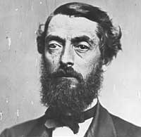
Henry Bergh was born on August 29, 1813 (died 1888).  The term “born with a silver spoon in his mouth” could have been coined to describe Bergh.  His father was a wealthy shipbuilder in New York City, but considered an honest, fair and responsible man.  His mother was equally gentle and considerate.  Henry inherited those qualities from his parents, along with a considerable fortune.

Bergh and his brother took over the family business and ran it successfully for several years before selling out and becoming men of leisure.  Bergh and his wife were “first night” socialites, generally appearing at the openings of plays, musical events and art exhibits in New York.  The Berghs traveled often to Europe, enjoying the best of life.  He loved the theater especially, and fashioned himself as a playright.  He wrote several plays, and convinced friends to stage them—all were dismal failures.

Portrait of Henry Bergh, by Benson John Lossing and George E. Perine

Because of his wealth and political connections, Bergh received a diplomatic posting from President Lincoln, serving in St. Petersburg, Russia.  While there, he experienced frightful treatment of animals, particularly work horses.  Once he observed a draft horse being whipped, he jumped from his carriage and confronted the horse’s owner.  That day, we are told, convinced Bergh that preventing cruelty to animals was his life’s work.  He resigned his diplomatic post and sailed back to New York.  On the way, he stopped in England to consult with the nation’s leading anti-cruelty advocate.

Back in New York, Bergh promoted his anti-cruelty message with passion and perseverence.  Animals should not be treated as property, he asserted, but as fellow creatures with whom we shared the earth. “This is a matter purely of conscience,” he wrote, “it has no perplexing side issues.  It is a moral question in all its aspects.” Although he couldn’t write plays, he could write provocative and persuasive letters to newspapers, politicians and rich patrons.  He soon convinced the state of New York to issue him authority to form the American Society for the Prevention of Cruelty to Animals (ASPCA), founded in 1866.

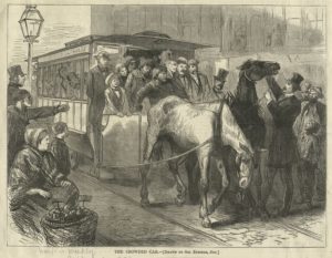
Within two weeks, the New York legislature passed an anti-cruelty law and put the ASPCA in charge of enforcing the new law.  Bergh went to work with a staff of officers.  He roamed the streets of New York, often in the worst neighborhoods and in the dark of night.  With the new law in his pocket, he accosted anyone seen mistreating an animal.  If a simple lecture did not deter the offender, Bergh would drag him from his seat to demonstrate his authority and courage.  He went after the treatment of work animals first, but also challenged dog-fighting and cock-fighting and the mistreatment of domestic animals.  He created the first ambulances, for transporting sick and injured horses to veterinarians—his horse ambulances were the model for their later use for humans!

Contemporary lithograph of Henry Bergh confronting the driver of malnourished and mistreated draft horses.

Bergh received both praise and criticism for his efforts.  His supporters called him “An Angel in Top Hat.”  His detractors called him “The Great Meddler.”  He withstood death threats and physical beatings.  He clashed with P. T. Barnum over the treatment of circus animals, carrying out a high-profile public debate.  In the end, Bergh won over Barnum, who changed his practices.

And, in the end, of course, he has convinced modern society to treat animals humanely.  His founded the first anti-cruelty organization in the U.S., with many thousands of similar groups now working effectively across this country and the world.

And how does this relate to conservation?  The expansion of ethical treatment from people to domesticated animals is an essential step on the road to the protection of wild creatures, then wild places and, finally to a sustainable earth.  Organizations that protest the inhumane treatment of animals work side-by-side with more direct conservation organizations to help people understand that all of creation needs our help—and we will perish without the rest of creation.  “Mercy to animals,” Bergh wrote, “means mercy to mankind.”

References:

ASPCA.  History of the ASPCA.  Available at:  https://www.aspca.org/about-us/history-of-the-aspca.  Accessed July 10, 2018.

Ferguson, Mark.  2007.  Henry Bergh.  Dictionary of Unitarian & Universalist Biography, April 22, 2007.  Available at:  http://uudb.org/articles/henrybergh.html.  Accessed July 10, 2018.

O’Reilly, Edward.  2012.  Henry Bergh:  Angel in Top Hat or the Great Meddler?  New York Historical Society, March 21, 2012.  Available at:  http://blog.nyhistory.org/henry-bergh-angel-in-top-hat-or-the-great-meddler/.  Accessed July 10, 2018.

Zawikowski, Stephen.  Bergh, Henry.  Learning to Give.org.  Available at:  https://www.learningtogive.org/resources/bergh-henry.  Accessed July 10, 2108.

Roger Tory Peterson, Ornithologist, Born (1908)

Seven million of us have a copy.  Mine sits on a table by the kitchen windows, next to the binoculars. I use it almost every morning.  A Field Guide to the Birds, by Roger Tory Peterson.  I’ve tried other bird guides, but I can’t break the habit to pick up Peterson’s book.  Nor should I.  Roger Tory Peterson is the man who made birdwatchers out of all of us.

Roger Tory Peterson was born on August 28, 1908, in Jamestown, New York (died 1996).  He wasn’t like other children—they called him strange—and his parents had trouble understanding him.  He was quiet, troublesome at school, often fell asleep in class.  Then a teacher, Blanche Hornbeck, had her students all join the Junior Audubon Club; at age 11, Peterson had found his passion—birds.

He got a paper route so he could watch birds in the morning and earn money for a camera to photograph them.  He became a good student, but mostly in art classes.  As a teenager, he submitted paintings of birds to art shows—and won, often in competition with leading artists.  He graduated high school when he was 16, and he followed his father into the furniture business. His skill as an artist was soon recognized and he was taken off the assembly line to paint the decorative designs on fancy furniture.  His boss convinced him to go to art school, and he saved for two years to earn tuition.  From 1927-1929, he studied art in New York, eventually at the National Academy of Design.

To earn a living, he became a teacher in the Boston area, but birds remained his passion—observing them, photographing them, painting them.  He had an idea for a guide to birds that would be different than the complicated, taxonomically based bird guides of the time.  Instead, he grouped birds by their appearance, making comparisons easier.  He drew detailed pictures of birds, emphasizing their shapes, sizes, coloration, and individual features, like beaks, feet and tail shape.  He placed arrows pointing to the distinctive features that observers should look for.  He added simple, direct text about the birds’ ranges, flying patterns and songs.  It was a guide for the amateur, not the specialist.

He submitted the book to four publishers, all of whom rejected it.  He then sent it to Houghton-Mifflin, which decided to take a chance.  Not much of one, however.  They printed 2,000 copies and forced Peterson to forego royalties on the first 1,000 because the publisher needed to recover the cost of so many illustrations.

Surprise!  The first 2,000 copies sold out in two weeks!  It was a huge success, and gave birth to the modern hobby of bird watching.  Over time, A Field Guide to the Birds went through 4 editions and 47 re-printings, and remains constantly in print to this day.  In all, 7 million copies have been sold.  Peterson didn’t stop there, however, going on to write, illustrate or edit more than 50 field guides for birds, flowers and other groups.  Ecologist Paul Ehrlich credited Peterson as “the inventor of the modern field guide.”

Photo by Larry Nielsen

His approach of clear, simple illustrations with arrows pointing out important features was a clear winner.  When he was drafted into military service during World War II, he was assigned to create training manuals, and he adopted the same approach as in his bird guide.  The Air Corps, for example, created a guide for identifying planes based on their appearance, complete with arrows to emphasize distinctive features.

Based on the success of his bird guides, Peterson became one of America’s leading conservationists.  He worked for the Audubon Society for eight years as an educator and art director.  Teasing apart his skill as a teacher, artist and naturalist is impossible, as they all combined in his work.  He understood that animals, especially birds, could entice anyone to become a conservationist.  He wrote:

“The philosophy that I have worked under most of my life is that the serious study of natural history is an activity which has far-reaching effects in every aspect of a person’s life.  It ultimately makes people protective of the environment in a very committed way.  It is my opinion that the study of natural history should be the primary avenue for creating environmentalists…”

Few would doubt the impact that that approach has had on our environment and the conservation movement.  He is considered the father of American ornithology and received virtually every major conservation award that exists.  When President Jimmy Carter bestowed on Peterson the Presidential Medal of Freedom on June 9, 1980, Carter said:

“Roger Tory Peterson has achieved distinction as a consummate painter, writer, teacher and scientist. As an unabashed lover of birds and a distinguished ornithologist, he has furthered the study, appreciation and protection of birds the world over. And he has done more. He has impassioned thousands of Americans, and has awakened in millions across this land, a fondness for nature’s other two-legged creatures.”

So, next time you scurry for the bird book so you can decide if you’re looking at a White-throated Sparrow or a White-Crowned one, give it up for the man who pointed out the way—Roger Tory Peterson.

References:

Houghton-Mifflin Books.  Biography, Peterson Field Guides.  Available at:  http://www.houghtonmifflinbooks.com/peterson/rtp/biography.shtml.  Accessed July 9, 2018.

Patuxent Wildlife Research Center.  Roger Tory Peterson.  Available at:  https://www.pwrc.usgs.gov/resshow/perry/bios/PetersonRoger.htm.  Accessed July 9, 2018.

Roger Tory Peterson Institute of Natural History.  Biography.  Available at:  https://rtpi.org/roger-tory-peterson/roger-tory-peterson-biography/.  Accessed July 9, 2018.

Severo, Richard.  1996.  Roger Peterson, 87, The Nation’s Guide To the Birds, Is Dead.  The New York Times, July 30, 1996.  Available at:  https://www.nytimes.com/1996/07/30/us/roger-peterson-87-the-nation-s-guide-to-the-birds-is-dead.html.  Accessed July 9, 2018.

First Oil Well Drilled (1859)

August 27 is known in some circles as Oil and Gas Industry Appreciation Day.  It’s a pretty low-key affair, and I can’t find information about why the industry picked August 27—but I think I know the reason.  This date, in 1859, is also when Edwin Drake drilled the first successful oil well in the world.

Interest about oil had been growing for some time.  It oozed out of the ground in various places, including far northwestern Pennsylvania.  People had been making kerosene for lamps from coal, but chemists had figured out how to make kerosene from oil, a far easier process than converting coal to a liquid.  Others discovered—maybe—that oil was an elixir that could cure a variety of ailments, including the dreaded “consumption” (now we call it tuberculosis).

But finding oil in commercial quantities was tough.  The basic method was to gather it from pools on the ground where it seeped to the surface, a process that might yield a few quarts a day. Drilling with traditional techniques used for water wells or brine wells (used to bring dissolved salt to the surface) failed to produce oil.  The Seneca Oil Company of Connecticut was founded to develop new techniques, and they hired retired Edwin Drake to lead the efforts in northwestern Pennsylvania.

Edwin L. Drake

Drake was born in New York in 1819.  He became a railroad conductor, running routes in New York and Pennsylvania.  He developed a debilitating muscular condition and after eight years on the railroad, was forced to retire.  Unemployed, he and his family moved to Titusville, Pennsylvania.  Drake knew one of the owners of the Seneca Oil Company and when they met by chance in Titusville, Drake was offered the job to manage their oil-drilling efforts.

Drake set up shop in Titusville, Pennsylvania.  Working with an experienced local well driller, William Smith, Drake spent months trying and failing to perfect a drilling technique. His efforts earned the local nickname “Drake’s Folly.”  Eventually, investors abandoned Drake, and his workers began to doubt his sanity, calling him “Crazy Drake.”  But his drilling innovation—a pipe that surrounded the drill bit and kept the bore hole stable—made the difference.  Drilling three feet per day, they stopped on the evening of August 26, 1859, when the well was 69.5 feet deep.  The next morning, oil had floated to the top of the hole—and history had been made!

Photo of Edwin Drake (right) with his first oil well in the background

The well was soon producing 40 barrels of oil per day.  One observer noted that Drake’s well could produce in a few days the same amount of oil as a whaling ship on a four-year voyage.  Western Pennsylvania became the center of the oil industry, producing half of the world’s supply for the next 40 years. Colonel Drake (he was not a military man, but adopted the rank anyhow) went from a goat to a hero.

From that first oil well (which is now part of a fascinating museum at the site), of course, the modern world has been built upon an oil and gas economy.  More than 4 million oil wells have been drilled in the U.S. alone.  Oil supplies one-third of all the energy consumed worldwide, and 98% of fuel used for transportation.  The world consumes 1.5 million gallons of oil products (gasoline, diesel and kerosene, primarily) per minute.  Per minute!  That’s about 50 million barrels, or 2 billion gallons, per day.

Americans love our cars, and the rest of the world is growing to love theirs.  About 1.2 billion cars are traveling the world’s roads now, and that number will continue to rise.  Americans have about 82 cars per 100 people, while China has about 7 and India about 4.  As other forms of transportation develop, other fuel uses will also increase.  Consumption of jet fuel, for example, has doubled in the last two decades.

And despite dire warnings about running out of oil, that isn’t about to happen anytime soon.  Petroleum scientists keep discovering new sources of oil, so that reserves have not changed in decades, despite increasing extraction.  Drake’s first oil well was step one of a seemingly unending process of finding more sources of oil in more places throughout the world.

From Drake’s first well sprang an industry. This is the Desdemona, Texas oil field in 1919 (photo by Almeron Newman Photographic Company)

Oil has been one of several sources of our advanced society, with high quality of life for increasing billions of people.  But, of course, there is a dark side.  Burning oil produces greenhouse gases.  While coal is the worst fuel to burn in terms of CO2 emissions per energy unit produced (over 200 pounds per BTU), diesel and gasoline come in second (around 150 pounds per BTU).  China today emits the most greenhouse gases (about 28% of the total); the U.S. is second with 16.5%, and the European Union is third, with 11.4%.  Rounding out the top ten emitters are India, Russia, Japan, South Korea, Iran, Canada and Saudi Arabia.  Together, the top ten emit 78% of the world’s greenhouse gases.

So, two lessons remain clear.  First, there is still a lot of oil and the world’s economy still runs on it.  Second, if we are going to slow down or stop climate change, we have to reduce the impact of burning fossil fuels—either with new technologies to reduce emissions or alternative fuels to replace oil and gas.  What we need, I think, is a new generation of Edwin Drakes, willing to be called crazy as they work to make our world sustainable.

References:

American Oil & Gas Historical Society.  First American Oil Well.  Available at:  https://aoghs.org/petroleum-pioneers/american-oil-history/.  Accessed July 7, 2018.

Clemente, Jude.  2015.  Three Reasons Oil Will Continue to Run the World.  Forbes Magazine, April 19, 2015.  Available at:  https://www.forbes.com/sites/judeclemente/2015/04/19/three-reasons-oil-will-continue-to-run-the-world/#325d13f143f9.  Accessed July 7, 2018.

Davooe, Urja.  2008.  Edwin Drake and the Oil Well Drill Piple.  Pennsylvania Center for the Book.  Available at:  https://pabook.libraries.psu.edu/literary-cultural-heritage-map-pa/feature-articles/edwin-drake-and-oil-well-drill-pipe.  Accessed July7, 2018.

Friedrich, Johannes and Thomas Damassa.  2014.  The History of Carbon Dioxide Emissions.  World Resources Institute, May 21, 2014.  Available at:  http://www.wri.org/blog/2014/05/history-carbon-dioxide-emissions.  Accessed July 7, 2018.

U.S. Energy Information Administration.  How much carbon dioxide is produced when different fuels are burned?  Available at:  https://www.eia.gov/tools/faqs/faq.php?id=73&t=11.  Accessed July 7, 2018.

Krakatau Volcano Erupted (1883)

Long before Mount St. Helens erupted, the most famous volcanic eruption in modern times occurred in Indonesia—when the volcano on Krakatau Island erupted.  It has allowed an ecological “experiment” to be followed for more than a century.

Krakatau is an island between Java and Sumatra, previously dominated by a group of ancient volcanic cones.  During the spring of 1883, plumes of ash and smoke at least six miles high appeared above the island, delighting some observers and worrying others.

1883 eruption of Krakatau (Lithograph – Parker & Coward, Britain, 1888)

The worriers were right.  About 1 PM on August 26, a major eruption occurred, blasting ash and smoke 15 miles high.  Much of the discharged material fell back into the cone, blocking further emissions and causing pressure to build up.  The next morning, the earth roared, a sounds that could be heard 2,800 miles away in Australia.  Four catastrophic blasts followed in rapid succession, a total force ten times greater than the Mount St. Helens eruption. A super-heated steam cloud spread for 25 miles around the blast.  A tsunami launched a 120-foot wall of water that drowned nearby towns.  More than 36,000 persons perished.

Map of Krakatau and nearby islands, showing the loss of land from the 1883 eruuption (Illustration by USGS)

When the eruption ended, the northern half of the island of Krakatau had been blasted away or sunk into the sea.  The island is now only about 5.5 miles long and 3 miles wide, about half its original size.  Since the 1930s, however, a small volcanic cone, called Anak Krakatau (Child of Krakatau) has grown from the submerged part of the island.  Anak Krakatau has continued to experience small eruptions since then, building the size and height of the cone, and frightening those who live in the region (the last major eruption was in 2007).

The destruction caused by the Krakatau eruption was a human tragedy, but it has also provided a location to study ecological succession like no other.  All life was destroyed on Krakatau and two small adjacent islands.  Because of the complete extinction and because there are ecologically diverse islands nearby, watching subsequent changes to the island has provided scientists with a rare chance to study ecology on a large scale, without ethical questions about destroying life or ecosystems to understand them.

Of particular interest has been, studying patterns of ecological colonization and succession, testing a theory by ecologists Robert Whittaker and E. O. Wilson  known as “island biogeography.”  They supposed that barren islands accumulated colonizing species at an initially rapid rate that slowed to an equilibrium as the number of new colonizing species equalled earlier colonists that were becoming locally extinct through competition and habitat change.

The data from Krakatau confirmed their theory in most ways.  Many studies of the flora and fauna of the island have been conducted over the past century.  Although the lava flows had sterilized the land surface, layers of ash provided habitat for plant colonists.  The coastal areas developed first, followed by interior grasslands and then forests.  Although the island contains relatively few tree species compared to mature tropical rainforests, forests now cover most of the island.  As plants colonized, so did invertebrates and eventually vertebrates, including birds, reptiles and mammals.  In each case, a period of rapid colonization has been followed by a gradual leveling off.

A 2001 satellite view of Krakatau and nearby islands, showing the plant cover that has recolonized the islands (photo by Semhur, NASA)

Anak Krakatau provides another interesting site.  Because it has continued to erupt, the island’s successional path has been chaotic, with reversals and repetitive patterns of arrival and disappearance of species.  This confirms the more modern interpretation of ecological succession as a dynamic process, pushed and pulled in different directions by the disturbances that are common, not rare, in nature.

References:

Bagley, Mary.  2017.  Krakatao Volcano:  Facts About 1883 Eruption.  Live Science, September 14, 2017.  Available at:  https://www.livescience.com/28186-krakatoa.html.  Accessed July 5, 2018.

Bush, Mark B. and Robert J. Whittaker.  1991.  Krakatau:  colonization patterns and hierarchies.  Journal of Biogeography (1991) 18:341-356.  Available at:  http://www.sfu.ca/geog315-new/readings/Bush_Whittaker_91.pdf.  Accessed July 5, 2018.

Thornton, I. W. B. et al.  1988.  Colonization of the Krakatau Islands by vertebrates :  Equilibrium, succession, and possible delayed extinction.  Proceeding of the National Academy of Sciences U.S.  85:515-518.  Available at:  https://www.ncbi.nlm.nih.gov/pmc/articles/PMC279581/pdf/pnas00254-0224.pdf.  Accessed July 5, 2018.

National Park Service Born (1916)

A few years ago, PBS and film-maker Ken Burns combined to produce the documentary series, “The National Parks—America’s Best Idea.”  Many of us would agree—the 400+ units of the National Park Service are a treasure beyond accounting.  And why have those treasures been preserved and prospered over a century dominated by growing population and development?  Because an “Organic Act” established the National Park Service on August 25, 1916.

Of course, the national park idea itself preceded the National Park Service (NPS) by about half a century.  President Lincoln established the first national park, Yosemite, in 1864, but gave management of it to the state of California.  Eight years later, in 1872, President Grant established the first official national park—Yellowstone.  A few other parks were created in the following decades.  Preserving public lands took a big leap forward in 1906, when President Teddy Roosevelt signed the Antiquities Act, which gave presidents the power to declare federal land protected as national monuments.

But this was a haphazard process.  Some protected lands were under the Secretary of Interior, others under the Secretary of Agriculture, and still others under the Secretary of War.  And protection itself was always in doubt, as proven in 1913, when two dams were authorized inside Yosemite National Park to provide water and power for San Francisco.  A better system was needed if our great national treasures were to survive.

Stephen Mather had a plan.  Mather was a California businessman who made “20-mule-team Borax” a highly popular cleaning product; and that product made Mather a very rich man.  But he also suffered from what we now call bipolar disease, and being outdoors in nature helped him escape the bouts of depression that plagued him.  He appreciated nature for himself, but he also understood that nature was part of America’s innate personality.  Visiting Yosemite and Sequoia National Parks in 1914, he despaired over their poor management and care.  He lobbied his friend, Secretary of Interior Franklin Lane, to do something.  Lane did—he offered Mather the job as his Assistant Secretary in charge of parks.

Mather, along with colleague Horace Albright, took on the challenge.  They improved the situation as best they could, hiring staff (which Mather paid with his own funds), expanding parks (with land purchased by Mather himself), professionalizing the training and procedures at parks and encouraging visitation.  But they understood that the great mission of their agency needed higher status if it were to prosper.  Along with other dedicated conservationists, Mather and Albright lobbied congress for two years, achieving their goal of a National Park Service Organic Act when President Wilson signed the agency into existence on August 25, 2016.

A depression-era poster that depicts an essential mission of the National Park Service–conserving wildlife.

An “organic act” is important because it establishes a federal land-management agency through passage of a law approved by both houses of Congress and signed by the President.  Therefore, the agency cannot be changed administratively—reorganized, eliminated, combined, broken apart, given a new mission—like other parts of the executive branch.  An organic act gives an agency permanency, exactly what is needed for the part of our government devoted to preserving our national treasures for all time.

The NPS Organic Act established the National Park Service, and gave it several specific features.  First, it gave the NPS jurisdiction of all “national parks, monuments and reservations,” moving lands from other agencies to the NPS.  From 35 units in 1916, the NPS continued to grow, with transfers of lands from other agencies and the addition of newly created parks and other areas through time.  Today, the NPS system includes 417 separate “units” covering 84 million acres.  Some are huge, like Yellowstone, others are small, just a historic building and its surrounding lands.

Second, the organic act defined the purpose of the NPS.  That purpose is “to conserve the scenery and the natural and historic objects and the wild life therein and to provide for the enjoyment of the same in such manner and by such means as will leave them unimpaired for the enjoyment of future generations.”  The act answered the question of whether resources could be exploited in national parks—and the answer is “no.”

Third, the organic act gave the NPS authority to use whatever tools and techniques it required to accomplish its mission.  Rules and regulations can be set to avoid damage and control use.  Resources can be managed—timber cut, animals harvested, facilities built—to protect the ecosystems and allow their use.  NPS units are not wildernesses (although parts of some are), but meant to be accessible to and enjoyed by visitors.  And visit them we do.  In 2017, the NPS reported total recreational visitors of 330,882,751—more than one visit on average by every person in the United States.

NPS employee Sheldon Johnson in Yosemite National Park.

Stephen Mather became the first Director of the National Park Service, a job he held from 1916 to 1929, just before his death.  Plaques erected in his honor in all parks at the time read, “There will never come an end to the good that he has done.”  Americans disagree about many things today, but I suspect that we would be nearly unanimous that there is no end to the good that our national parks have done—and will do.

References:

Dilsaver, Lary M.  1994.  America’s National Park System—The Critical Documents.  Rowman & Littlefield Publishers.  Available at:  https://www.nps.gov/parkhistory/online_books/anps/index.htm.  Accessed July 3, 2018.

National Park Service.  Quick History of the National Park Service.  Available at:  https://www.nps.gov/articles/quick-nps-history.htm.  Accessed July 3, 2018.

PBS.  Stephen Mather (1867-1930).  The National Parks, America’s Best Idea.  Available at:  http://www.pbs.org/nationalparks/people/nps/mather/.  Accessed July 3, 2018.

Katahdin Woods and Waters National Monument, Maine, Established (2016)

For decades, outdoor enthusiasts have wished for—and worked for—a national park in northern Maine.  In 2016, their wish came true, partially, when President Barack Obama declared an 87,500-acre tract as the 413th unit of the National Park Service.  On August 24, Katahdin Woods and Waters National Monument became real.

The path to a new NPS property has been as rugged as the country that it now occupies.  The northern region of Maine, an area of more than 10 million acres known as the North Woods, remains one of the most remote, undeveloped parts of the eastern U.S.  During 1820-1860, most of that land was sold by the state of Maine in huge parcels to timber companies.  For more than a century, timber companies cut trees sustainably, made paper, provided good jobs and maintained a laissez-faire attitude toward other traditional uses of the land—hunting, fishing, hiking and later snowmobiling—by local residents.  And those local residents, famous for their independence and distrust of outsiders, liked it that way.

Katahdin Woods and Waters National Monument (photo by U..S. Department of the Interior)

But as the 21st Century approached, the timber economy started to decline.  Several mills went bankrupt and timber companies began selling off their lands.   Even before that, as the northeastern U.S. began to fill up, some Maine leaders saw the need to put land, even in Maine’s remote North Woods, into protected status.  For decades, former governor Percival Baxter bought up lands around Maine’s highest mountain, Mt. Katahdin (5,268 feet in elevation), and eventually donated the land to the state to become Baxter State Park, established in 1931.

Fast forward 70 years to 2011, when Roxanne Quimby announced she wished to donate land in the North Woods to make a national park.  Quimby had moved to Maine in 1975, where she began a small company with a local beekeeper, Burt Shavitz.  They sold beeswax candles and then hit on a product—Burt’s Bees lip balm—that made them wealthy.  Quimby began buying land, including 87,500 acres just east of Baxter State Park.

She donated those acres to the U.S. government for a park, along with $20 million to support its development and another $20 million promised for the future.  President Obama signed the park into law on August 24, 2016.

Katahdin Woods and Waters National Monument (photo by U.S. Department of the Interior)

Not everyone is happy about the new national monument.  Some local residents object to their loss of free access to the land—commercial timber harvest is illegal, snowmobiling is restricted to just parts of the area, but fishing and hunting and other recreational uses are still allowed.  The current governor, Paul LePage, has been a fierce opponent of the national monument, and refused to allow information signs about the park to be posted along state roads.  He convinced President Trump to include Katahdin as the only eastern national monument in a review of large monuments that had been approved since 1996.

Although some individuals and local governments still object to the park, the mass of public opinion is in favor.  Public and private groups, including businesses, have endorsed the park, as have the majority of public comments submitted in various reviews.  Secretary of the Interior Ryan Zinke issued his report in August, 2017.  He recommended that Katahdin remain a national monument, with no changes in size, but did suggest that timber harvest be allowed to promote a “healthy forest.”  No further action on that recommendation has occurred.  And local businesses are beginning to see an uptick in tourism that they hoped for, to replace the declining timber economy.

Katahdin Woods and Waters National Monument, however, remains a largely undiscovered gem.  Fewer than 30,000 people visited last year (the National Park Service’s visitor statistics site doesn’t even include the park yet).  If you are looking for an eastern park unlikely to be overrun by tourists, head to northern Maine—your campsite, although primitive, awaits!

References:

Abel, David.  2017.  In Maine, a national monument may be in peril.  The Boston Globe, July 30, 2017.  Available at:  https://www.bostonglobe.com/metro/2017/07/30/national-monument-peril/pKqoFMHCMVJzNfm5s2hVmO/story.html.  Accessed July 2, 2018.

Domonoske, Camila.  2016.  In Maine, Land From Burt’s Bees Co-Founder Is Declared A National Monument.  NPR, August 24, 2016.  Available at:  https://www.npr.org/sections/thetwo-way/2016/08/24/491206413/in-maine-land-from-burts-bees-co-founder-is-declared-a-national-monument.  Accessed July 2, 2018.

Miller, Kevin.  2017.  Interior secretary wants to keep Maine’s Katahdin Woods and Waters National Monument.  Portland Press Herald, August 24, 2017.  Available at:  https://www.pressherald.com/2017/08/24/interior-secretary-wants-to-keep-national-monument-in-maine/.  Accessed July 2, 2018.

Natural Resources Council of Maine.  National Monument Timeline.  Available at:  https://www.nrcm.org/projects/forests-wildlife/katahdin-national-monument/national-monument-timeline/.  Accessed July 2, 2018.

Hetch Hetchy Began Producing Power (1925)

It is known as the first major environmental controversy in United States history.  It broke John Muir’s heart.  To this day, it remains as controversial as when it was built.  “It” is the damming of the Hetch Hetchy Valley in Yosemite National Park to provide water and power to San Francisco.

According to John Muir, the Hetch Hetchy Valley was the twin to the world-famous Yosemite Valley.  The area was inside the borders of Yosemite National Park, and, therefore, was protected from any exploitation.

Or so it seemed.  But San Francisco needed water, and it coveted the clean, clear, reliable supplies from the high Sierras.  For many reasons, the Hetch Hetchy Valley of the Tuolumne River was the perfect spot for a dam and reservoir.  Others thought it the worst of ideas, as John Muir stated:  “Dam Hetch Hetchy! As well dam for water-tanks the people’s cathedrals and churches, for no holier temple has ever been consecrated by the heart of man.”

The Hetch Hetchy Valley in 1908 or earlier, before damming and flooding (photo by Isaiah West Taber)

Forces aligned to protect Yosemite and to exploit it.  The battle to dam Hetch Hetchy had reached a stalemate until the 1906 fire destroyed much of San Francisco.  The city lacked water supplies to put out the fire.  After that disaster, the cause to save Hetch Hetchy was lost.  The Raker Act was introduced into Congress to allow two dams to be built in Yosemite; it quickly passed and was signed into law by President Woodrow Wilson on December 19, 1913 (a year later, dispirited by this act and the start of World War I, John Muir died).

Construction on the “Hetch Hetchy System” began soon afterward.  The project included two dams and reservoirs inside Yosemite National Park.  The first was Lake Eleanor, a relatively small project that produced power that was sold to support the cost of the bigger project in the Hetch Hetchy Valley.  The Tuolumne River was impounded by the O’Shaughnessy Dam, completed in May, 1923.  Originally 226 feet high, the dam was later raised to the current height of 312 feet.  The Dam flooded about nine miles of the river, including the Hetch Hetchy valley.

The main power facility in the system, the Moccasin Powerhouse, began commercial operation on August 14, 1925.  Some years later, water began flowing to San Francisco.  Since then, the “Hetch Hetchy System” has continued to grow, now including nine impoundments and three powerhouses.  The system provides about 75% of the water for San Francisco and surrounding communities, and about 20% of the region’s electricity.

The flooded Hetch Hetchy Valley in 2015 (photo by Erik Wilde)

More than 100 years after the dam’s approval, Hetch Hetchy still throbs with controversy.  Calls for removing the dam continue, as part of a nationwide trend to remove old and obsolete power dams and restore the submerged ecosystems.  Several Secretaries of the Interior, both Republican and Democratic, have floated the idea, but never implemented a process.  In 2012, San Franciscans voted on a ballot referendum to study the feasibility of dam removal and alternate water and energy supplies; 77% of voters said no, a resounding defeat.  Californians, perhaps more than citizens of any other state, know the value of water and are committed to renewable energy (although some renewable energy advocates reason that hydro-electricity is not greenhouse-gas neutral, that argument loses merit for a nearly century-old dam).  Despite the referendum defeat, pro-dam-removal groups have continued to raise legal arguments for removing the O’Shaughnessy Dam.

Dams represent one of the most interesting dilemmas on the route to a sustainable planet.  They are massive intrusions onto the landscape, with unavoidable consequences to the local environment (when a landscape is flooded, it changes) and often devastating consequences to people forced to move (although these are political rather than environmental failures).  However, dams provide reliable water supplies for irrigation, domestic and industrial uses.  They reduce flood damage and generate electricity without burning fossil fuels.

August 14, 1925 saw power first begin to flow from the Hetch Hetchy System, and it has continued to flow unabated since then.  And right along with it, the power of environmental controversy has also flowed, equally unabated.

References:

Bolin, Leslie K.  1987.  Hetch Hetchy:  Facts and Figures.  U.C. Davis Environmental Law Society.  Available at:  https://environs.law.ucdavis.edu/volumes/12/1/bolin.pdf.  Accessed June 30, 2018.

Restore Hetch Hetchy.  Hetch Hetchy Today.  Available at:  https://www.hetchhetchy.org/hetch_hetchy_today.  Accessed June 30, 2018.

San Franciscon Public Utilities Commission.  2005.  A History of the Municipal Water Department & Hetch Hetchy System.  Available at:  https://sfwater.org/modules/showdocument.aspx?documentid=5224.  Accessed June 30, 2018.

Sierra Club California.  Hetch hetchy—timeline of the ongoing battle over hetch hetchy.  Available at:  https://vault.sierraclub.org/ca/hetchhetchy/timeline.asp.  Accessed June 30, 2018.

Water Education Foundation.  Hetch Hetchy Reservoir and Water System.  Available at:  https://www.watereducation.org/aquapedia/hetch-hetchy-reservoir-and-water-system.  Accessed June 30, 2018.

Chile’s Atacama Desert Blooms (2017)

It is one of the driest places on earth.  Average rainfall is 0.5 inches per year; some areas have no recorded rainfall—ever.  But when it does rain, as it did leading up to August 23, 2017, watch out!  The desert blooms!

The Atacama Desert in Chile lies along the northwestern edge of the country, a thin line stretching for more than 600 miles, squeezed between the Pacific Ocean and the foot of the Andes mountains.  It is a high, cool desert, at an elevation of nearly 8,000 feet and with daytime temperatures only in the high 60s, Fahrenheit.

The Atacama Desert in its usual arid state in 2010 (photo by Christian Van Der Henst S.)

Even in its usual dry state, it is starkly beautiful.  Some areas are painted by a variety of mineral deposits—cobalt, gypsum, lamprophyre.  At sunset, the ringing mountains are bathed in orange and yellow.  At night, the lack of water vapor in the air and the absence of human settlements bring the sky to life.  So vivid is the night sky that the European Southern Observatory maintains two facilities in the area.

And every so often, at intervals of 5-7 years, a drenching rainfall produces what locals call the “desierto florido” or “flowering desert.”  That unusual rainfall occurred in early August, 2017, leading to the bloom centered on August 23.  The desert blooms as dormant seeds of more than 200 flowering plants burst from the soil.  The normally barren landscape is then carpeted in millions of colorful flowers, white, yellow, blue, purple.  Although individual flowers may last for only a few days, the different germination rates among species means the phenomenon as a whole lasts for several weeks.

The Atacama Desert in its “desierto florido” state, 2002 (photo by Javier Rubilar)

Most of us who love nature know that the desert teems with life.  Plants and animals have adapted to the harsh conditions, finding ways to harvest and retain water or being active only at night.  A hike through the Sonoran Desert of Arizona reveals abundant life from massive cacti to scurrying insects.

But the massive bloom of Atacama is an especially rare and beautiful reminder that we must be humble about our understanding of nature.  What we experience through human eyes on occasional forays into a desert is the equivalent of the small part of the iceberg that lies above the water’s surface.  What we don’t see or experience is the massive storehouse of life that hides from our casual understanding or observation.

One of my pet peeves is the environmentalist’s claim that nature is fragile.  Nonsense.  Nature isn’t fragile or weak or on the brink of destruction.  Nature is strong, resilient, dismissive of human attempts to corrupt it.  Yes, nature might not produce what we think is scenic or valuable at our command or on our schedule, but what nature produces of its own choosing is both mighty and awesome.

Sometimes the awe comes from the fearsome and immediate forces of a lightning strike or tornado.  Sometimes it comes from the slow, relentless forces of a drought or insect invasion.

But sometimes the awe comes from a desert floor awash in colorful blooms that we never knew were possible.  Look at nature with open eyes and an open mind—and be awed.

References:

BBC News.  Chile’s Atacama desert:  World’s driest place in bloom after surprise rain.  23 August 2017.  Available at:  https://www.bbc.com/news/world-latin-america-41021774.  Accessed June 27, 2018.

Encyclopedia Britannica.  Atacama Desert.  Available at:  https://www.britannica.com/place/Atacama-Desert.  Accessed June 27, 2018.

Gibbons, Sarah.  2017.  See One of Earth’s Driest Places Experience Rare Flower Boom.  National Georgaphic News, August 30, 2017.  Available at: https://news.nationalgeographic.com/2017/08/chile-atacama-desert-wildflower-super-bloom-video-spd/.  Accessed June 27, 2018.

Leadbeater, Chris.  Exploring Chile’s Atacama Desert.  National Georgraphic Travel.  Available at:  https://www.nationalgeographic.com/travel/destinations/south-america/chile/explore-chile-atacama-desert-stargazing/.  Accessed June 27, 2018.

“Bambi” Released (1942)

One of history’s most controversial films was released on August 21, 1942—Bambi.  How could an animated film about a white-tailed deer cause such furor?  How could discussion of the film become an industry in itself?  No doubt, it underlies our universal dilemma of both using and protecting nature simultaneously.

Bambi is a product of Walt Disney, the founder and long-time leader of one of the most successful entertainment companies in the world.  Disney began making full-length animated films in the late 1930s.  Bambi was supposed to be Disney’s second release, with production beginning in 1936, but it took so long to make that it became fifth, finally getting to theaters in 1942.  Disney wanted the film to be accurate and look good.  He sent artists to the Maine woods to sketch forest backgrounds for six months.  He received two white-tail fawns that artists used to model their drawings of body form and movements.  He required artists to work in oil rather than watercolor to make the scenes more vivid, slowing the work to a snail’s pace.  Getting the spots to move correctly on Bambi’s coat and making his father’s antlers look correct in all orientations presented particular obstacles.

The idea for the film was not original to Walt Disney, however.  It was based on a 1928 book, Bambi: A Life in the Woods, by Austrian author, journalists and critic Siegmun Salzmann (writing under the pseudonym Felix Salten).  Considered by many to be a metaphor for the treatment of Jews by the fascists, the book (and all of Salzmann’s work) was eventually outlawed in Nazi Germany.  Salzmann’s book, written for adults, describes the life journey of a male roe deer in a forest beset with dangers from humans and other animals.

Disney, as we all know, deviated from that script. He set the book in the United States, with the main character a white-tailed deer. In Disney’s Bambi, the animals are all friends, cavorting happily in the forest, sometimes hungry but usually enjoying the good life.  Until humans interrupts the utopia.  The warning cry goes up among the animals, “Man is in the forest.” Hunters kill Bambi’s mother (although that happens out of sight), then they go after other deer, including injuring Bambi, and accidentally setting the forest on fire.  Except for the death of Bambi’s mother, however, the rest turns out well, with Bambi becoming the new prince of the forest and siring a new generation of deer with Faline.

Reactions to Bambi were immediate and extreme.  Hunters immediately saw the film as anit-hunting, an Outdoor Life editor saying it was “the worst insult ever offered in any form to American sportsmen.”  The magazine tried to get Disney to include an introduction explaining that the film was a fantasy, not representative of ethical hunters.  A writer for Audubon, however, praised the film for raising the environmental consciousness of the general population, comparing it to the impact of Uncle Tom’s Cabin on views of slavery.  And the controversy and rhetoric have never cooled off, with terms like the Bambi effect, Bambi factor, Bambi Syndrome and Bambi backlash still firing up admirers and haters.  In 1980, George Regier wrote in Field & Stream that “Naturally once Bambi is raised in status from mere deer to Jesus Whitetail Superstar, man’s hunting of deer becomes a crime comparable to the persecution of Christ.”

Bambi and Faline (photo by Walt Disney)

The film itself is one of the most successful in Disney’s catalogue of animated features.  At first it lost money, but re-releases over time have filled the Disney treasury.  Gross proceeds from the film are around $300 million worldwide, not counting a long list of commercial spinoffs.  The American Film Institute considers it among the top ten animated features of all time.

So, we can either blame Bambi for making a sentimental mess of our approach to managing natural resources, or we can thank Bambi for being one among many Disney messages cautioning us to pay attention to how we treat the natural world.  Take your choice.  But you have to agree that Thumper is one cute rabbit!

References:

Class Movie Hub.  Bambi.  Available at:  http://www.classicmoviehub.com/facts-and-trivia/film/bambi-1942/page/1/.  Accessed June 26, 2018.

Lutts, Ralph H.  1992.  The Trouble with Bambi:  Walt Disney’s Bambi and the American Vision of Nature.  Forest and Conservtion History 36 (October 1992):160-171.  Available at:  https://www.history.vt.edu/Barrow/Hist2104/readings/bambi.html.  Accessed June 26, 2018.

Murray, Robin L. and Joseph K. Heumann.  2016.  How ‘Bambi’ Hoowinked American Environmentalists.  What it Means to Be American, April 19, 2016.  Available at:  http://www.whatitmeanstobeamerican.org/ideas/how-bambi-hoodwinked-american-environmentalists/.  Accessed June 26, 2018.

University of Cambridge.  2008.  The Bambi Factor.  Available at:  https://www.cam.ac.uk/news/the-%E2%80%9Cbambi-factor%E2%80%9D.  Accessed June 26, 2018.

Roald Amundsen Completes Northwest Passage (1905-1906)

The Northwest Passage—a sea route across the Arctic region between the Atlantic and Pacific Oceans—had been a dream for centuries.  It became a reality in 1905 when Norwegian explorer Roald Amundsen completed the journey.  Today, climate change has made what was once a dream into a certainty.

The mariners who tried to find the Northwest Passage reads like a who’s who of explorers.  Christopher Columbus, John Cabot, Henry Hudson, James Cook, James Franklin and, finally and successfully, Roald Amundsen.  Amundsen lived from 1872 to 1928 and conducted many polar expeditions.  His most famous was his traverse of the Northwest Passage, which occurred from 1903 to 1906.

Arctic explorer Roald Amundsen, 1912

He had studied other attempts to cross the Arctic Sea, all of which ended in failure.  He decided to try another tactic, using a small fishing ship, the Gjoa (70 feet long, but with a very shallow draft), and a small crew (seven men) that would allow flexibility and access to shallow waters.  They left the southern coast of Greenland in summer of 1903 and picked their way through the ice up, across and down Baffin Island and somewhat farther west, stopping at King William Island.  There, at a protected bay they named Gjoa Haven, they stayed for two years, learning survival skills from the native Inuits, taking scientific measurements and searching for the magnetic North Pole.

Roald Amundsen’s ship, Gjoa, a small fishing boat that could navigate shallow waters.

On August 13, 1905, they set sail again, heading west through narrow and shallow straits.  A few days later, they encountered a whaling ship headed east, and Amundsen knew he had completed his quest.  As he wrote in his diary, “The North West Passage was done. My boyhood dream—at that moment it was accomplished. A strange feeling welled up in my throat; I was somewhat over-strained and worn—it was weakness in me—but I felt tears in my eyes. ‘Vessel in sight… Vessel in sight.’”  They were soon iced-in again and spent another winter before landing at Nome, Alaska, the following August (perhaps on August 13 again, but I can’t confirm the date).

Amundsen’s achievement was world news, but it had little practical impact.  He used routes too shallow for commercial vessels and spent years to accomplish the journey.  Various other voyages, using modern ice-breaking ships, managed to make the journey in recent decades, but those outcomes were still novelties.

Climate change, however, is changing all that.  The Arctic region is warming much faster than the rest of the world, taking sea ice with it.  Arctic sea ice has dropped by about 1.3% per year since the 1970s.  An ice-free passage between the Atlantic and Pacific opened for the first time in history in 2007.

Possible routes for the Northwest Passage (the lower one approximates Amundsen’s route) (image by NASA)

Commercial ship travel has begun, with a still-modest record of 30 ships making the transit in 2012.  In 2016, a luxury cruise ship, the Crystal Serenity, made the trip from Alaska to New York, charging up to $50,000 for a stateroom.  The increase in commerce raises many questions about the future of the Arctic.  Increased exploitation of oil, minerals, forests and wildlife is likely.  A legal fight over ownership is developing between Canada, through whose territory any Northwest Passage route will flow, and other Arctic nations, who claim joint sovereignty of the region through treaties.

Ecological impacts are also likely as the climate warms and the ice continues to melt.  Migration of species between the oceans will occur—gray whales from the Pacific have recently been seen in the north Atlantic.  The poor condition of individual polar bears, which rely on sea ice as their primary habitat, has been broadly reported, but the impact on populations of polar bears remains unknown because of scarce data.

References:

ArcGIS.  Roald Amundsen Northwest Passage Map.  Available at:  https://www.arcgis.com/home/webmap/viewer.html?webmap=605b5c99c1ad42678ddfa6b1d47cbc7d.  Accessed June 15, 2018.

History.com  Northwest Passage.  Available at:  https://www.history.com/topics/northwest-passage.  Accessed June 15, 2018.

Kahn, Brian.  2016.  This Is What the Ice-Free Northwest Passage Looks Like.  Climate Central, August 23, 2016.  Available at:  http://www.climatecentral.org/news/ice-free-northwest-passage-20624.  Accessed June 15, 2018.

King, Hobart M.  What is the Northwest Passage?  Geology.com.  Available at:  https://geology.com/articles/northwest-passage.shtml.  Accessed June 15, 2018.

Royal Museums Greenwich.  Roald Amundsen North-West Passage expedition 1903-1906.  Available at:  https://www.rmg.co.uk/discover/explore/roald-amundsen-north-west-passage-expedition-1903%E2%80%9306.  Accessed June 15, 2018.

This Month in Conservation

April 1
Wangari Maathai, Kenyan Conservationist, Born (1940)
April 2
Maria Sibylla Merian, German Entomologist, Born (1647)
April 3
Jane Goodall, Chimpanzee Researcher, Born (1934)
April 4
“The Good Life” Begins Airing (1975)
April 5
Civilian Conservation Corps (CCC) Created (1933)
April 6
American Museum of Natural History Founded (1869)
April 7
World Health Day
April 8
A Tribute to the Endangered Species Act
April 9
Jim Fowler, “Wild Kingdom” Co-host, Born (1932)
April 10
Arbor Day First Celebrated (1872)
April 11
Ian Redmond, Primatologist, Born (1954)
April 12
Arches National Monument Created (1929)
April 13
First Elephant Arrives in U.S. (1796)
April 14
Black Sunday Dust Storm (1935)
April 15
Nikolaas Tinbergen, Animal Behaviorist, Born (1907)
April 16
Ling-Ling and Hsing-Hsing Arrive in U.S. (1972)
April 17
Ford Mustang Introduced (1964)
April 18
Natural History Museum, London, Opened (1881)
April 19
E. Lucy Braun, Plant Ecologist, Born (1889)
April 20
Gro Harlem Brundtland, Godmother of Sustainable Development, Born (1939)
April 21
John Muir, Father of American Conservation, Born (1838)
April 22
The First Earth Day (1970)
April 23
World Book Day
April 24
Tomitaro Makino, Father of Japanese Botany, Born (1862)
April 25
Theodore Roosevelt National Park Established (1947)
April 26
John James Audubon Born (1785)
April 27
Soil Conservation Service Created (1935)
April 28
Mexican Gray Wolf Listed as Endangered (1976)
April 28
Chernobyl Nuclear Accident Announced (1986)
April 29
Emmeline Moore, Pioneering Fisheries Scientist, Born (1872)
April 29
Dancing with Nature’s Stars
April 30
First State Hunting License Fee Enacted (1864)
January February March April May June July August September October November December