Blog

Mount St. Helens Erupts (1980)

David A. Johnston, a U.S. Geological Survey scientist, was camped near Mount St. Helens on the morning of May 18, 1980.  He had been stationed there to monitor smaller earthquakes and eruptions on the mountain over the previous several months.  That morning, at 8:32, he radioed, “This is it!”  And it was.  Mount St. Helens erupted that morning, destroying 200 the surrounding landscape and killing 57 people, including Johnston.

Mount St. Helens, in central Washington, was one of the beautiful, cone-shaped mountains of the Cascades, standing tall at 9600 feet above sea level.  The mountain, like others in the volcanically active Cascade Range, had experienced eruptions before, one around 1800 that might have been bigger than the modern eruption.  But this one was different.  A magnitude-5.1 earthquake under the mountain dislodged the north-facing slope, creating the largest landslide ever recorded—anywhere on earth.  Then the volcano erupted through the barren flank, sending a wave of rock and ash sideways, instantly destroying 200 square miles of forest.  Eruptions followed from the top of the mountain, spewing ash and smoke 12 miles into the air.  The mountain’s height dropped by 1300 feet.  A wave of mud moved across the landscape at 90 miles per hour.

Eruption of Mount St. Helens on May 18, 1980 (photo by USGS/Austin Post)

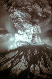
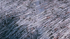
The destruction to the ecosystem was enormous.  In the blast zone, trees were laid flat; 4 billion board-feet of timber were lost, enough to build 500,000 homes.  Spirit Lake, just below the mountain, was covered in ash and completely disappeared, along with 15 miles of the North Fork Toutle River.  Along with the 57 human fatalities, an estimated 11 million fish, 1 million birds and about 20,000 large mammals perished.  The federal government estimated the total damage at $1.1 billion.

Trees blown down by eruption of Mount St. Helens (photo by USGS/J. G. Rosenbaum)

The eruption itself is a testament to the power of nature, but even more remarkable is the recovery.  Observers at the time expected recovery of the ecosystem to take generations, perhaps centuries.  But once again, nature demonstrated the power and resilience of natural processes.  The federal government created the Mount St. Helens National Volcanic Monument (a U. S. Forest Service property) so that scientists could study the natural recovery process.

The pace and scope of recovery have surprised everyone.  Within days, insects had returned.  Within weeks, plants were sprouting.  Lupines, which are able to fix nitrogen from the air and thus take advantage of the available landscape, populated quickly, their beautiful flowered stalks decorating the ashy grey ground.  The river quickly reformed a channel to carry melting water and rainwater from the newly sculpted mountainside.  Likewise, Spirit Lake began to reform, capturing the runoff water.  Elk have returned to graze on the lush vegetation.

The natural recovery of the Mount St. Helens ecosystem, 2011 (photo by Theo Crazzloara)

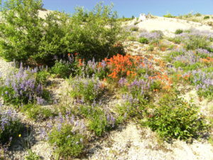
Today, nearly 40 years after the eruption, the Mount St. Helens ecosystem is a laboratory that challenges much of what we had thought about succession.  The ecosystem is not the same, so the ecological processes are less about recovery than about creation.  Spirit Lake, for example, which had been a relatively barren cold-water lake is now shallower, more productive and more diverse.  Coniferous forests have been replaced in many areas by deciduous forests of alders, which also can fix nitrogen from the air.

The lesson, I believe, is not that nature is fragile, but that nature is tough.  A physical process like a volcano, earthquake, flood or drought may have profound acute impacts, but the persistent and patient biological processes that follow will create a new ecosystem as interesting, beautiful and productive as the one it replaced.  In the end, nature wins.

References:

Bagley, Mary.  2013.  Mount St. Helens Eruption:  Facts & Information.  Live Science, February 23, 2013.  Available at:  https://www.livescience.com/27553-mount-st-helens-eruption.html.  Accessed May 18, 2018.

Casey, Michael.  2015.  35 years after Mount St. Helens eruption, nature returns.  CBS News, May 18, 2015.  Available at:  https://www.cbsnews.com/news/35-years-after-mt-st-helens-eruption-nature-returns/.  Accessed May 16, 2018.

Lindsey, Rebecca.  1984.  Devastation and Recovery at Mt. St. Helens.  NASA Earth Observatory, June 17, 1984.  Available at:  https://earthobservatory.nasa.gov/Features/WorldOfChange/sthelens.php.  Accessed May 18, 2018.

Swenson, Keith and David Catchpoole.  2012.  After devastation … the recovery.  Creation Ministries International, 14 November 2012.  Available at:  https://creation.com/after-devastation-the-recovery.  Accessed May 18, 2018.

Australian BioBanking for Biodiversity Implemented (2010)

The Australian state of New South Wales completed its first biobanking agreement on May 17, 2010.  The agreement placed 80 hectares of native vegetation into a permanent preserve in exchange for $1.7 million.  This particular reserve includes 36 hectares of the critically endangered Cumberland Plain ecosystem, which is home to 17 threatened species.

Biobanking is one class of “ex situ conservation,” which seeks to compensate for environmental degradation in one place by improving or protecting the environment in another place.  The method has been used in the U.S. since the 1970s for wetland mitigation.  For example, if a road must be built through a wetland, then a comparable piece of wetland somewhere else needs to be protected or improved.  The protected wetlands are in “mitigation banks” created by other landowners who are willing to maintain their lands as permanent, maintained wetlands in exchange for a financial payment.  Many nations have similar limited programs for specific types of habitats or the habitats of endangered species.

The biobanking scheme in New South Wales was created by the Threatened Species Conservation Act of 1995, but it took many years to be implemented.  It is a complex scheme with several significant elements.  First, an assessment process was required that could evaluate a piece of ground and determine what biodiversity values were either being destroyed by its development or enhanced by its protection and maintenance.   Biodiversity value relates to the composition, structure and function of ecosystems, a more comprehensive definition than is typically used in environmental assessments.

Second, sites need to be enrolled that become the lands to be protected or enhanced.  In the first case in New South Wales, 80 hectares were enrolled by the Missionaries of the Sacred Heart, who own the site in southwest Sydney.  Protecting urban lands, like those around Sydney, is particularly important in Australia, where development and high-priority environmental lands often overlap.  The program now lists 83 land parcels that have enrolled, and the website lists 158 needs for additional lands to be enrolled.

Third, a market needs to be established that allows developers to buy “credits” from the protected lands.  This is handled in New South Wales by the Ministry of Climate Change, Environment and Water.  The market price includes two elements.  First is a price for a trust fund that the government operates that uses investment returns to pay landowners for their annual costs of maintaining and improving the property.  That trust fund currently has a $50 million balance.  Second is a price for the value of the credits themselves, that the property owner can determine based on competition.  In the case of the first New South Wales property listed, the trust fund cost was $555,000 and the value of the credits themselves was $1.1 million.

Although some conservationists feel such ex situ conservation schemes are inappropriate because they fail to protect all sites everywhere, most believe that this represents a positive step.  It helps to put economic values on conservation so conservation can be compared to other land uses, and it engages private enterprise in the sustainability journey, a process that most experts believe is both desirable and inevitable.  Expect more of this, not less.

References:

Financial Review.  2010.  NSW:  BioBank scheme to reduce diversity, criticis say.  Financial Review, May 17, 2010.  Available at:  http://www.afr.com/news/politics/nsw-biobank-scheme-to-reduce-diversity-critics-say-20100517-ivj8w.  Accessed May 15, 2018.

NSW Environmental Trust.  2016.  Annual Report, 2015-2106.  Available at:  http://www.environment.nsw.gov.au/resources/grants/160581-annual-report-2016-trust.pdf.  Accessed May 15, 2018.

Rodricks, Sasha.  2010.  Biodiversity banking and offset scheme of New South Wales (NSW), Australia.  TEEBcase.  Available at:  http://img.teebweb.org/wp-content/uploads/2013/01/Biodiversity-Banking-and-Offset-scheme-New-South-Wales-Australia.pdf.  Accessed May 15, 2018.

UNDP.  Biodiversity Offsets.  Available at:  https://www.undp.org/content/sdfinance/en/home/solutions/biodiversity-offset.html.  Accessed May 15, 2018.

Ramon Margalef, Pioneering Ecologist, Born (1919)

One of the world’s greatest ecologists and one of Spain’s great scientists was Ramon Margalef, born May 16, 1919 (died 2004).  Margalef lived through—and broadly influenced—the development of ecology into a mature and meaningful scientific discipline.

Ramon Margalef i Lopez was born in Barcelona, where he said he “lost time in Trade School and other foolishness.”  As a boy, he loved to watch the life in water puddles, intrigued by the tiny organisms he saw swimming there.  Over time, that interest expanded into fish and other natural organisms and places.  He did not finish school, but was drafted into military service during the Spanish Civil War and later just before the start of WW2.  While serving, he collected fish and wrote scientific papers.

Afterwards, he attended college at the Universitat de Barcelona, striving through individual effort to understand a broad array of subjects. He built a microscope from flea-market purchases and many devices for field observations. He learned to speak six language, nutured a love of literature, and pursued physics, but his primary attraction remained the natural history of freshwaters.  He earned a BS degree in 1949 and a doctorate two years later (yes, in just two years).

He was a field biologists and ecological theoretician, noting that a good scientist should be proficient in both realms.  “The good ecologist,” he said, “should be able to screw down screws with a hammer and to sink nails with a screwdriver.”  He worked at the Spanish Fisheries Research Institute from 1949 to 1967.  In 1967, he was appointed Spain’s first professor of ecology, at the Universitat de Barcelona, where he remained until his retirement 20 years later.  He continued to work—out of a tiny office, it is said—until days before his death in 2004.

Ramon Margalef teaching in a field lab course (photo from Peters 2010 biography)

He was a prolific author, publishing more than 400 papers and numerous books.  His Spanish textbook on ecology was the standard for generations.  But it was a 102-page volume, published in 1968, based on a series of lectures he gave at the University of Chicago in 1966, that earned him a global reputation.  The book, Perspective in Ecological Theory, presented a way to look at ecology in terms of information theory—nature was organized and operated according to the precepts of information flow.  His approach fostered the analysis of the living world as a system, rather than a random assemblage of species.  His theories, sometimes wrong but always creative and stimulating to other ideas, allowed the flowering of systems ecology, quantitative analysis and synthesis of field observations into meaningful patterns.

He continued his personal interest in limnology and oceanography throughout his career.  He published a Spanish textbook on limnology that, like his ecology text, became a classic.  Although a highly praised theoretician, he maintained that he was really “just a naturalist.”  But he understood that “making lists [of species] to characterize different types of ecosystems” was an inadequate way to understand them.  He consolidated the immense range of his knowledge into “a multishaped cover of life.”

Ramon Margalef in 1973 (photo from Peters’ 2010 biography)

On a person note, I read Perspectives in Ecological Theory when I was a doctorate student in the early 1970s and have kept it close throughout my career.  Looking at my copy now, I remember my excitement at the insights it provided.  It is my most annotated book.  In the margin of page 41, I wrote, “It seems absolutely breathtaking that the patterns of life in the world could be theorized in this way! Fantastic.”

The rest of the world agreed with me.  Ramon Margalef is one of the most honored ecologists in history, awarded the highest scientific recognition available in Spain, France, Germany, Italy, and other countries.  Awards are named for him in several scientific societies, most notably the American Society of Limnology and Oceanography.

He was a humble man with a good sense of humor who excelled also at public education.  He wrote several books for the general audience that remain best-sellers in Spain.

His understanding of life as a system led him to two conclusions about conservation.  One, he included humans and their impacts as part of natural ecosystems, a novel idea in the 1960s and now a standard part of our approach.  Second, and following the first, he understood that human use of nature was both necessary and natural—but that overuse would cause the systems to destabilize. Humans shouldn’t use all the water in rivers, for example, because “wasted water in rivers is vital to ecosystems.”

References:

Eaude, Michael.  2004.  Ramon Margalef, Modest founding father of ecological science.  The Guardian, 31 May 2004.  Available at:  https://www.theguardian.com/news/2004/jun/01/guardianobituaries.research.  Accessed May 14, 2018 (note:  this article contains the incorrect date of Margalef’s birth).

Peters, Francesc.  2010. Ramon Margalef, The Curiousity Driven Life of a Self-Taught Naturalist.  Limnology and Oceanography Bulletin 19(1):2-14.

Ros, Joandomenec.  2004.  In memory of Ramon Margalef (1919-2004).  International Microbiology 7(3).  Available at:  http://scielo.isciii.es/scielo.php?script=sci_arttext&pid=S1139-67092004000300010&lng=en&nrm=iso&tlng=en.  Accessed May 14, 2018.

Declaration of the Conservation Conference (1908)

The beginning of the first U.S. environmental movement is often pegged to the 1908 Conference of Governors, which occurred during May 13-15.  The conference was the first meeting that called together the nation’s leaders to address the topic of conservation.

Teddy Roosevelt was president during this time, his terms running from 1901 to 1909.  He was an ardent conservationist, advised throughout his presidential term by another prominent conservationist—Gifford Pinchot.  Pinchot was the nation’s first chief forester, but more than that, he was a close advisor to Roosevelt on all areas of public policy.  Pinchot espoused a general principle that natural resources should be used sustainably, neither over-exploited nor under-exploited.

Conservation leaders Teddy Roosevelt and GIfford Pinchot, 1907 (photo by US Forest Service)

Pinchot, along with the leader of the Inland Waterways Commission, W. J. McGee, convinced Roosevelt that he should call the nation’s leaders together to confront what they all saw as the despoliation of America’s natural resources.  Accordingly, with McGee serving as the chief organizer of the event, Roosevelt invited hundreds of individuals to come to Washington for the conference.

Although themed as the governors’ conference, the attendees went far beyond state and territorial governors and their representatives.  Anyone who was anyone came.  The entire cabinet, all justices of the Supreme Court, senators and congresspersons, leaders of virtually all major business and philanthropic organizations (not just environmental groups, of which there were few), and representatives of federal and state agencies attended.

The attendees met for three days, with speeches and presentations covering a wide range of geographic locations and types of resources.  At the time, “natural resources” included agriculture, minerals and mining, water and forests—virtually everything that humans depended on from nature.  Certain aspects that we now consider essential parts of natural resources, such as biodiversity, weren’t represented—but it was early times for conservation.

The premise of conservation at the time was two-fold.  First, natural resources should not be over-used, so severely exploited that their productive capacity would be lost in the long run—soils should not be eroded, for example.  Second, natural resources should not be wasted, allowed to lie unused when the nation required all resources to fuel its prosperity—forests, for example, should be harvested to take advantage of the wood, the trees not left standing until they died or allowed to decompose once they had fallen.

The intense attention to resource management was needed because the country had not been paying attention.  As one senator stated, “Those who succeed us can well take care of themselves.”  And one representative said conservationists were “google-eyed, bandy-legged dudes from the East and sad-eyed, absent-minded professor and bugologists.”  At this time, however, soil erosion was rampant, wildlife species had been hunted to near extinction, and eastern forests had been virtually cleared.

Governors of the U.S. states and territories pictured with President Roosevelt during the 1908 Conservation Congress

The Governors’ Conference changed that laissez-faire attitude, perhaps by the sheer size and scope of the meeting.  At the conclusion, on May 15, the group issued a “Declaration of the Conservation Conference.”  Among its pronouncements were the following:

“We the Governors of the States and Territories of the United States of America, in Conference assembled, do hereby declare the conviction that the great prosperity of our country rests upon the abundant resources of the land chosen by our forefathers for their homes and where they laid the foundation of this great Nation.

We look upon these resources as a heritage to be made use of in establishing and promoting the comfort, prosperity, and happiness of the American People, but not to be wasted, deteriorated, or needlessly destroyed.

We declare our firm conviction that this conservation of our natural resources is a subject of transcendent importance, which should engage unremittingly the attention of the Nation, the States, and the People in earnest cooperation.

We declare the conviction that in the use of the natural resources our independent States are interdependent and bound together by ties of mutual benefits, responsibilities and duties.”

            The nation—and the world—has never looked back from that day onward.  The 20th Century saw the founding of most natural resource science disciplines, the creation or expansion of major federal conservation agencies, the parallel creation of state-level natural resource agencies, passage of laws to protect resources and the general growth of public awareness of and commitment to environmental sustainability.  (Also of note is that this meeting of governors was the start of annual governors’ conferences on various topics that led to the formation of the National Governors Association.)

We often say that we can see farther because we stand on the shoulders of the giants who preceded us.  Most of them were there in Washington in May, 1908.

References:

Conference of the Governors of the United States.  1909.  Proceedings.  Available at:  https://babel.hathitrust.org/cgi/pt?id=nnc1.cu09109439;view=1up;seq=2.  Accessed May 11, 2018.

Dorsey, Leroy G.  2016.  Theodore Roosevelt, Conservation, and the 1908 Governors’ Conference.  Texas A&M Press, College Station.  Available at:  https://www.questia.com/library/120093465/theodore-roosevelt-conservation-and-the-1908-governors.  Accessed May 11, 2018.

Library of Congress.  Today in History – May 13.  Available at:  https://www.loc.gov/item/today-in-history/may-13/.  Accessed May 11, 2018.

PBS.  Declaration of the Conservation Conference, May 15, 1908.  Available at:  http://www.pbs.org/weta/thewest/resources/archives/eight/conconf.htm.  Accessed May 11, 2108.

Lewis and Clark Expedition Began (1804)

The most famous explorers of the American west are Meriwether Lewis and William Clark, who traveled from St. Louis to the Pacific Ocean and back during 1804-1806.  The story of their adventure is a foundation of American folklore.

Meriwether Lewis was an experienced soldier and frontiersman who also served as personal secretary to President Thomas Jefferson.  Jefferson asked Lewis to undertake a journey across the west, to chronicle the natural history, draw maps and make peace with the Native Americans who lived in the region.  Lewis asked his former military leader, William Clark, to join him on the expedition as co-leader.  Clark was also a veteran frontiersman and a skilled draughtsman.  Together they gathered a crew of about 40 men and the necessary supplies to make the trip.

Meriwether Lewis and William Clark

The group—known as the Corps of Discovery—set off on May 14, 1804, from Camp Wood, near St. Louis, Missouri.  They poled, paddled and pulled their boats up the Missouri River into present-day North Dakota, where they built Fort Mandan and stayed for the winter.  The next spring, they set off again up the Missouri, reaching the headwaters.  Their hope to find a water route that joined the Pacific with the Mississippi River failed, and they were guided across the mountains by Shoshone Indians.  Eventually reaching the Columbia River, they floated downstream to the Pacific Ocean, where they stayed during the winter of 1805.  The following spring, they made the return trip, completing their journey at St. Louis in September 1806.  The total journey covered approximately 8,000 miles.

Map of the Lewis and Clark Expedition, 1804-1806.

Lewis and Clark contributed greatly to our understanding of the West.  They sent back descriptions and specimens of 178 plants and 122 animals previously undescribed by science, including the grizzly bear, prairie dog, pronghorn antelope, sagebrush, Douglas fir and ponderosa pine.  They drew remarkably detailed and accurate maps of the entire region, used as the standard maps until the 1840s.  They dealt peacefully with many Native American nations, and their success was in many ways tied to the help of those native peoples; the most famous of which was Sacagawea, who accompanied the expedition for much of the time.

References:

Buckley, Jay H.  2018.  Lewis and Clark Expedition.  Encyclopedia Britannica.  Available at:  https://www.britannica.com/event/Lewis-and-Clark-Expedition.  Accessed May 10, 2018.

Clark, Linda Darus.  Lewis & Clark Expedition (adaptation).  National Archives.  Available at:  https://www.archives.gov/education/lessons/lewis-clark.  Accessed May 10, 2018.

History. Com.  Lewis and Clark.  Available at:  https://www.history.com/topics/lewis-and-clark.  Accessed May 10, 2018.

St. Lawrence Seaway Authorized (1954)

One of the world’s great watersheds begins in the tributaries to Lake Superior, flows through the other four Great Lakes (Michigan, Huron, Erie and Ontario) and then follows the St. Lawrence River into the northern Atlantic Ocean.  The lakes and rivers form the U.S.-Canada border from Michigan to New York.  And for hundreds of years, humans have been modifying the watercourse to allow easier navigation.  That effort took a major leap forward on May 13, 1954, when both Canada and the U.S. signed laws to create the St. Lawrence Seaway.

St. Lawrence Seaway (photo by Ad Meskens)

The watercourse runs for 2340 miles from Lake Superior to the mouth of the St. Lawrence River.  Although long stretches are readily navigable, obstacles to transportation exist at several places, with shallow depths, rapids and waterfalls—including the famous Niagara Falls between Lake Erie and Lake Ontario.  As early as 1680, engineers began working on canals and locks to bypass those obstacles.

The most significant of the early efforts was the construction of the Welland Canal, which bypasses Niagara Falls.  Canada completed the Welland Canal in 1833, with 40 wooden locks over its 27-mile length, which made the four upper Great Lakes accessible from the sea.  But much work remained, and the two nations started planning for a full deep-water system in 1895.

That plan arrived on May 13, 1954, when both countries passed parallel laws creating the authority to proceed. Over the next five years, the two countries spent $470 million to complete the system (Canada paid 70%).  The system included 15 locks (13 in Canada, 2 in the U.S.) and deepening of the channel so that ships up to 740 feet long, 78 feet wide and drawing 26.5 feet of water could make the entire journey from ocean to Lake Superior.

The seaway has been a major boon for the industries of the upper Midwest.  The seaway is open for much of the year, setting a record for ice-free operation in 2017 of 298 days.  In 2017, 4,119 ships passed through the system, carrying 38 million tons of materials.  Major cargoes are iron ore, coal, limestone, grain and other construction and industrial raw materials.

Unfortunately from an ecological perspective, the seaway also transports unintended cargo—non-native and invasive species.  In earlier years, ships would empty the ballast water they carried when they arrived at a port—along with the water came many living species that could survive in the holds on the journey (today, ballast water needs to be exchanged before a ship enters freshwater).  The obstacles to boat traffic were also obstacles to the movement of species; their removal has allowed species to migrate upstream.  Organisms also attach to the hulls of ships or get caught on propellers and other external parts of ships.

For all these reasons, the Great Lakes above Lake Ontario have become home to more than 180 species that are not native.  Most are of minor or localized concern, but several have become very abundant (that is, invasive) and cause significant damage to the ecosystem.

Among the worst is the sea lamprey, a parasitic fish that worked its way up the system when canals and locks allowed them to bypass obstacles.  Sea lampreys attach to the sides of fish, drilling holes in the flesh and draining fluids from their host.  Invasions of sea lampreys totally changed the fish assemblage of the Great Lakes, reducing the native lake trout to near extinction.  In response, fisheries agencies introduced Pacific salmon and spends millions every year to control sea lampreys.

Sea lampreys attached to salmonid

A second disastrous species is the zebra mussel, which invaded through ballast water.  The zebra mussel is a European species that developed massive populations in the Great Lakes.  The large populations filter lake water at a large scale, consuming the micro-organisms that fed the rest of the native food-chain.  They also create large encrustations on water intake and discharge pipes, reducing the effectiveness of water supply and electric power generating plants.

Zebra mussels encrusted on a native mussel shell (photo by U.S. Fish and Wildlife Service)

Other species of concern are non-native plants, such as purple loosestrife and Eurasian watermilfoil, and other fish, such as Asian carp species (silver and bighead carp).  Despite efforts to combat the entry of non-native species, the very nature of the system—opening the waterway and allowing a continuous stream of boat traffic—means the invasion will continue.  A 2012 study estimated that the total of these aquatic invasive species caused damages, lost income and containment costs of about $100 million per year—that cost will never go away.

References:

NOAA.  Great Lakes Region—Invasive Species.  Available at:  http://www.regions.noaa.gov/great-lakes/index.php/great_lakes-restoration-initiative/invasive-species/.  Accessed May 10, 2018.

Rosaen, Alex L. and others.  2012.  The Costs of Aquatic Invasive Species to Great Lakes States.  Anderson Economic Group.  Available at:  https://www.nature.org/ourinitiatives/regions/northamerica/areas/greatlakes/ais-economic-report.pdf.  Accessed May 10, 2018.

Saint Lawrence Seaway Development Corporation.  2018.  The Great Lakes-St. Lawrence Seaway System.  Available at:  https://www.seaway.dot.gov/about/great-lakes-st-lawrence-seaway-system.  Accessed May 10, 2108.

The St. Lawrence Seaway Management Corporation.  Seaway History.  Available at:  http://www.greatlakes-seaway.com/en/seaway/history/.  Accessed May 10, 2018.

Farley Mowat, Author of “Never Cry Wolf,” Born (1921)

We all love wolves today, but that was not the case 50 years ago.  Wolves were thought to be ferocious predators that killed for fun as well as food.  Among the events that changed our thinking was the 1963 book, Never Cry Wolf, written by Farley Mowat.

Mowat was born in Ontario on May 12, 1921 (died 2014).   The family moved often, as his librarian father sought work farther and farther west.  Their mode of transport was as unique as their son would become:  they traveled in a ship’s cabin attached to a Model T truck frame that they called Rolling Home. They settled in Saskatoon, Saskatchewan, during the Depression.  Mowat became a lover of wild nature, even keeping a rattlesnake as a pet.  He visited the Arctic with an uncle when he was 15, fueling a lifelong interest in Arctic environments and peoples.  He fought in World War 2, including serving behind enemy lines in the Netherlands to coordinate a food drop that saved thousands of lives.

After the war, Mowat’s career as a storytelling author began.  In all, he wrote 45 books that have been translated into 52 languages and sold 17 million copies.  His books range from whimsical tales about animals for children to hard-hitting exposes of the treatment of Native Peoples in the Arctic.  Topics for his work ranged from the life of gorilla biologist Dian Fossey to the exploitation of whales in Newfoundland, to tales of his war experiences to the general slaughter of all animals species.

Farley Mowat being inducted into Canada’s Walk of Fame in 2010 (photo by Tabercil)

He considered his work to lie between non-fiction and fiction, stating that he was suspicious of facts because they could be used to distort more fundamental truths.  He wrote, “Having eschewed the purely factual approach, I was not willing to go to the other extreme and take the easy way out by writing fiction.  My métier lay somewhere in between what was then a grey void between fact and fiction.”

His most famous book is Never Cry Wolf, published in 1963.  In 1946, he spent a season as a lone biologist, dropped in the wilderness of northern Manitoba to study the life of wolves.  His account portrayed wolves as gentle, loving animals that cared for their young and killed only what they needed to eat.  And they often survived on mice (which Womat tried himself and quite liked).  He described one adult male wolf as the ideal father:  “Conscientious to a fault, thoughtful of others, and affectionate within reasonable bounds, he was the kind of father whose idealized image appears in many wistful books of human family reminiscences.”

His books were either loved or hated.  Obviously, most peopled loved his work as he became one of Canada’s most popular authors.  But others criticized his casual relationship with the facts, naming him not Farley Mowat, but “Hardly Know-it.”  He was once denied entry into the United States, in 1985, because he was considered a subversive.

Nevertheless, his work on many topics—wolves, commercial whaling, treatment of native peoples—helped establish and motivate the modern environmental movement.  Elizabeth May, a Canadian environmental politician, noted that Mowat “…was telling stories that made you laugh out loud, but which made you see that the natural world was a big part of who we are.”

References:

Austen, Ian.  2014.  Farley Mowat, Author, Dies at 92; a Champion of the Far North.  The New York Times, May 7, 2014.  Available at:  https://www.nytimes.com/2014/05/08/world/americas/farley-mowat-canadian-writer-and-wildlife-advocate-dies-at-92.html.  Accessed May 9, 2018.

Historic Canada.  Farley Mowat.  Available at:  http://www.thecanadianencyclopedia.ca/en/article/farley-mowat/.  Accessed May 9, 2018.

Parini, Jay.  2014.  Farley Mowat obituary.  The Guardian, 8 May 2014.  Available at:  https://www.theguardian.com/environment/2014/may/08/farley-mowat.  Accessed May 9, 2018.

“HMS Beagle” Launched (1820)

This conservation calendar could include a story almost every day of the year about Charles Darwin and the second voyage of the Beagle.  And there are a few scattered through the year.  But today is special, because May 11, 1820, is the birthday of the boat that carried Darwin, HMS Beagle.

Beagle was born at the Woowich Dockyard in London.  The dockyard was one of two built in the early 1500s by order of Henry VIII, who wanted boat-building to occur near his palace at Greenwich.  Hundreds of ships were built at Woolwich and its companion, Deptford, over the centuries.

Beagle was built originally as an armed vessel, known as a brig (i.e, it had two masts).  It carried ten cannons that could be used as needed during scouting and courier missions.  The boat was 90 feet long and 24.5 feet wide.   However, the Royal Navy found no immediate use for the capabilities of Beagle.

HMS Beagle in the Straits of Magellan

So, the ship was refitted to become a surveying vessel in 1825.  The changes made the ship into a “bark” by adding a third mast.  It was sent on its first voyage in 1826, a four-year survey of South America’s coastline.  The original captain committed suicide on the voyage, and command was taken over by Robert Fitzroy.

Portrait of Admiral Robert Fitzroy, Captain of HMS Beagle (photo by Royal Naval College)

The second voyage of the Beagle is the one we all remember.  Fitzroy remained the ship’s captain.  Beagle was again re-built, raising the deck a foot and adding an outer hull of wood to increase its strength and flexibility.  The task of the voyage was to sail around South America and then the entire earth, completing accurate measurements of the longitude of the earth.  It carried a host of surveying and other experimental equipment, including 22 clocks (necessary to plot location) and lightning conductors.  It carried a large crew, 68 in all, that made the ship incredibly crowded.  Fitzroy thought the ship was perfect for the task at hand:

 “Never, I believe, did a vessel leave England better provided, or fitted for the service she was destined to perform, and for the health and comfort of her crew, than the Beagle. If we did want any thing which could have been carried, it was our own fault; for all that was asked for, from the Dockyard, Victualling Department, Navy Board, or Admiralty, was granted.”

The second voyage lasted from 1831 to 1836.  The ship was gone for 1742 days and traveled almost 40,000 miles.

Among the 68 crewmen was Charles Darwin.  His task was to observe the natural history of the locations they visited, most of which were still barely explored.  “Natural history” in those days included plants, animals, geology and fossils.  To say that he enjoyed himself would be a classic understatement:

“The voyage of the Beagle has been by far the most important event in my life, and has determined my whole career …. I have always felt that I owe to the voyage the first real training or education of my mind; I was led to attend closely to several branches of natural history, and thus my powers of observation were improved….”

And the rest, as we say, is history.  Darwin spent two decades researching the specimens he brought back and working out the concepts of natural selection and evolution.

While Darwin was working on his data and ideas, Beagle was not idle.  The ship went back to sea the next year, on a six-year voyage to survey the coast of Australia.  But three voyages were enough—in 1845, the Beagle’s masts were removed and the hull was moored in the estuary near Essex, England, to discourage smugglers.  It was renamed Watch Vessel 7.  After 25 years of such service, in 1870 what remained of the ship was decommissioned, broken apart and sold for scrap.

References:

HMS Beagle Project.  Charles Darwin Describes His Time Aboard the Beagle.  Available at:  http://www.hmsbeagleproject.org/timeline/charles-darwin-describes-his-time-aboard-beagle/.  Accessed May 7, 2018.

Royal Museums Greenwich.  HMS Beagle.  Available at:  https://www.rmg.co.uk/discover/explore/hms-beagle.  Accessed May 7, 2018.

Thomson, Keith S.  Beagle (ship).  Encyclopedia Britannica.  Available at:  https://www.britannica.com/topic/Beagle-ship.  Accessed May 7, 2018.

Today in Science.  Beagle Quotes.  Today in Science History.  Available at:  https://todayinsci.com/QuotationsCategories/B_Cat/Beagle-Quotations.htm.  Accessed May 7, 2018.

Birute Galdikas, Orangutan Expert, Born (1946)

Most of us enjoyed reading stories about Curious George, the mischievous monkey, and his friend, the Man in the Yellow Hat.  But for one six-year-old with her first library book, Curious George created a defining moment—she would be an explorer and study primates.

Birute Mary Galdikas was born on May 10, 1946, while her Lithuanian parents were traveling to a new home in North America.  She grew up in Canada, but moved later with her family to the United States.  She earned anthropology degrees at UCLA.

While a graduate student there, she met the famous paleontologist Louis Leakey.  She wanted to follow in the footsteps of two other women he mentored, Jane Goodall and Dian Fossey.  But she wanted to study orangutans in Indonesia, a task that Leakey thought was more difficult.  She was persistent, however, and Leakey warmed to the idea.  In 1971, he found funding for her to begin her studies.

With her photographer husband, Galdikas set up a research station—named Camp Leakey—at the Tanjung Putting Reserve in Borneo, Indonesia.  Orangutans are mostly solitary and they live in swampy forests, both factors that made her research difficult, but also important.  Little was known about orangutans when she started working.

Like Goodall and Fossey, Galdikas’ patience and persistence paid off.  The orangutans got used to her and accepted her observations.  And what she learned changed our perceptions of the species.  While adult males are highly solitary and competitive, females and young are less so.  Females only give birth once every eight years, the longest interval between reproduction known in the animal world.  The animals feed on more than 400 foods, taking advantage of whatever is available.  They are highly intelligent, and researchers were able to teach individuals sign language.

Dr. Birute Galdikas in 2011 (photo by Simon Fraser University, University Communications)

Galdikas’ work has brought the ecology of orangutans to both scientists and the public.  A cover story in National Geographic in 1975 cemented her prominence as an orangutan biologist.  She remained in Borneo for 40 years studying orangutans, a record for one researcher observing one species at the same location.  Although not as famous as Goodall and Fossey—partly, she believes, because she stayed rooted in her Borneo research camp—her work has had a major influence on our knowledge of and concern for orangutans.  Her work has been featured repeatedly in National Geographic, in major newspapers, on television and in several film documentaries.

As the orangutans became popular, Gadikas’ work gained prominence.  She has been awarded many honors for her work, including being the only foreign-born person to win Indonesia’s Kalataru Award, the country’s top prize for environmental work.  In 1986, she and a group of supporters established the Orangutan Foundation International (OFI), headquartered in Los Angeles and with branches around the world.  The foundation supports global efforts to study and protect wild orangutans.  She still splits her time between the foundation’s headquarters and her research camp in Borneo.

Bornean orangutan (photo by Julielangford)

She remains fundamentally concerned about the sustainability of orangutan populations in the wild.  IUCN classifies the species as “critically endangered,” because of illegal hunting and habitat loss from illegal logging.  Forest fires that ravaged Indonesia during the late 1990s had a major impact on orangutan habitat.  In a 2000 interview with The New York Times, she said:

“I feel like I’m viewing an animal holocaust and holocaust is not a word I use lightly. The machine of extinction is grinding away. The destruction of the tropical rain forest in Borneo is accelerating daily. The consequences of this destruction for the orangutans will be final. And if orangutans go extinct in the wild, paradise is gone. And we’ll never have it again.”

She continues her research work not only to advance knowledge, but also to provide a steady presence for conservation in rural Borneo.  Rural people need jobs that come from keeping the animals alive and the forests intact.  Galdikas believes that “one of the best things that can happen to a forest is to have researchers there.  They attract attention and get the government to enforce protections. Even if it is just a ‘paper park’ [where rules aren’t enforced very well] they can protect habitat, because developers are reluctant to do anything permanent, like create a plantation.”

So, she stays. And because she does, so do the orangutans.  Curious George would be proud.

References:

Dreifus, Claudia.  200.  Scientist at Work/Birute Galdikas; Saving the Orangutan, Preserving Paradise.  The New York Times, March 21, 2000.  Available at:  https://www.nytimes.com/2000/03/21/science/scientist-at-work-birute-galdikas-saving-the-orangutan-preserving-paradise.html.  Accessed May 7, 2018.

Nature.  2005.  Pioneering Primatologist.  PBS, February 13, 2005.  Available at:  http://www.pbs.org/wnet/nature/orphan-king-pioneering-primatologist/11410/.  Accessed May 7, 2018.

Orangutan Foundation International.  Dr. Birute May Galdikas.  Available at:  https://orangutan.org/about/dr-birute-mary-galdikas/.  Accessed May 7, 2018.

Thames River Embankments Completed (1874)

London in the 1850s was a stinking mess.  Air pollution was terrible, but water pollution had reached the breaking point.  An engineer named Joseph Bazalgette changed much of that by building the Thames Embankments.  The final section, called the Chelsea Embankment, was opened on May 9, 1874, by Prince Alfred, completing one of the great engineering projects of the Victorian Era.

London was a huge city by the 1850s, with millions of residents.  But it had nothing close to an organized sanitation system.  Where sewers did exist, they emptied into scores of small rivers that ran open and putrid to the Thames—which also ran putrid.  Things got really bad in the summer of 1858, known as the year of the Great Stink.  Abnormally low flows in the Thames coupled with abnormally high temperatures made the Thames a swamp of stinking human wastes.  So bad was the stench that Parliament had to suspend operations and Queen Victoria, out for a cruise down the river, was turned back after a few minutes.

Something had to be done, and the engineer Joseph Bazalgette had the answer.  He proposed to build a series of giant sewers that ran along the two banks of the Thames, collecting the outfall of smaller sewers and carrying them miles downstream, beyond the sight—and smell—of Londoners.  The project was approved, and Bazalgette set to work.

Contemporary drawing of the construction of the Thames River Embankments (photo by The Illustrated London News)

His project wasn’t just a set of sewer pipes.  It involved the entire transformation of the Thames River in central London.  Up to then, the Thames had broad, sloping banks that formed wide mud flats at low tide.  Bazalgette’s project narrowed the river within high straight stone walls.  Behind the walls and below the ground surface, he built sewers, of course, but also tunnels for trains (the famous London Underground) and channels for other needs, like electric cables and telephone lines.  On top, he built a road, with walkways along the river and on the land side of the road.  Gardens planted with trees at 20-foot intervals filled the intervening spaces.

The project was immense, and expensive.  Begun in 1859, it continued through 1874.  The total project includes the Albert, Thames and Chelsea Embankments, covering both sides of the river for a distance of more than five miles.  Bazalgette not only solved the current issues, but  anticipated the future.  He estimated the population of London, generously estimated how much each person would produce in sewage, and then doubled that amount to accommodate future growth.  The capacity of his sewers served the city for 80 years, until new capacity had to be designed.

The results produced marked improvements in public health.  Cholera, which is spread through contaminated water and had occurred in regular outbreaks in London, basically disappeared in the area covered by the new structures.  Public pride also soared.  A river that Londoners were “converting…into a sewer” became “a magnificent promenade.”

Bazalgette’s achievement is one example of the growing concern that Americans and Europeans had for their diminished environments during the last half of the 19th Century.  As the nastiest leavings of the industrial movement made shambles of urban areas around the civilized world, a growing movement began—and we all benefit from it today.

References:

Broich, John.  2013.  London—Water and the Making of the Modern City.  University of Pittsburgh Press, 214 pages (p. 47-48).

Grace’s guide to British Industrial History.  Joseph Bazalgette.  Available at:  https://www.gracesguide.co.uk/Joseph_Bazalgette.  Accessed May 4, 2018.

This Month in Conservation

April 1
Wangari Maathai, Kenyan Conservationist, Born (1940)
April 2
Maria Sibylla Merian, German Entomologist, Born (1647)
April 3
Jane Goodall, Chimpanzee Researcher, Born (1934)
April 4
“The Good Life” Begins Airing (1975)
April 5
Civilian Conservation Corps (CCC) Created (1933)
April 6
American Museum of Natural History Founded (1869)
April 7
World Health Day
April 8
A Tribute to the Endangered Species Act
April 9
Jim Fowler, “Wild Kingdom” Co-host, Born (1932)
April 10
Arbor Day First Celebrated (1872)
April 11
Ian Redmond, Primatologist, Born (1954)
April 12
Arches National Monument Created (1929)
April 13
First Elephant Arrives in U.S. (1796)
April 14
Black Sunday Dust Storm (1935)
April 15
Nikolaas Tinbergen, Animal Behaviorist, Born (1907)
April 16
Ling-Ling and Hsing-Hsing Arrive in U.S. (1972)
April 17
Ford Mustang Introduced (1964)
April 18
Natural History Museum, London, Opened (1881)
April 19
E. Lucy Braun, Plant Ecologist, Born (1889)
April 20
Gro Harlem Brundtland, Godmother of Sustainable Development, Born (1939)
April 21
John Muir, Father of American Conservation, Born (1838)
April 22
The First Earth Day (1970)
April 23
World Book Day
April 24
Tomitaro Makino, Father of Japanese Botany, Born (1862)
April 25
Theodore Roosevelt National Park Established (1947)
April 26
John James Audubon Born (1785)
April 27
Soil Conservation Service Created (1935)
April 28
Mexican Gray Wolf Listed as Endangered (1976)
April 28
Chernobyl Nuclear Accident Announced (1986)
April 29
Emmeline Moore, Pioneering Fisheries Scientist, Born (1872)
April 29
Dancing with Nature’s Stars
April 30
First State Hunting License Fee Enacted (1864)
January February March April May June July August September October November December