Blog

Costa Rica Constitution Enacted (1949)

The codification of a nation’s constitution may seem like an odd entry for a conservation calendar, but Costa Rica made an enormous sustainability decision with one simple eight-word statement—Article 12:  “The Army as a permanent institution is proscribed.”  Instead of funding an army, Costa Rica chose to fund peace and prosperity, creating an educated, healthy and environmentally conscious society.

Costa Rica stands out from other Latin American countries by its stable government and commitment to peace.  That commitment was made law when it passed a new constitution on November 7, 1949.   It was the first nation in the world to make such a decision.

Two other notable parts of the constitution further determined the course of Costa Rica’s future.  The constitution guarantees free education to all citizens.  As a consequence, Costa Rica has a 99% literary rate, among the highest in the world.  Combined with other social programs, Costa Ricans are healthy and happy—the happiest nation in the world, according to several indices.

Regarding the environment, Article 50 of the constitution makes environmental quality explicit:  “All person have the right to a healthy and ecologically balanced environment.”  Article 89 further codifies the Costa Rican commitment “to protect the natural beauties….”

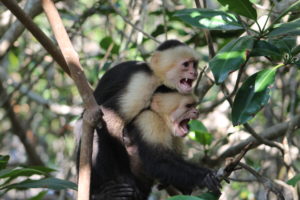
We are fortunate that Costa Rica had the foresight to recognize its exceptional ecological treasures and to conserve those for their own and our benefit.  The country has protected more land—about 25% of the surface area—in parks and other reserves than any country in the world.  Good thing, because Costa Rica holds 6% of the earth’s biodiversity in just 0.03% of the land area.  As a consequence, ecotourism is the country’s largest industry and has reduced poverty in rural areas by 16%.  They are doing well by doing good.

            And the world keeps beating a path to Costa Rica’s door.  Nearly 3 million people visited the country in 2016.  Most were from the U.S. (about 40%) and Europe (about 20%).  The average American visit was 11 days, focused almost entirely on the natural wonders of the nation.   

Costa Rica’s commitment to sustainability does not end with national parks and ecotourism.  The nation has declared a goal to become the world’s first carbon-neutral state by 2021, the date of its bicentennial (a few other countries are competing for that honor, as well).  Their electricity already is about 98% renewable, mostly from hydro-electric dams, but also from wind, solar and geothermal.  They intend to offset any ongoing emissions from diesel transportation by increasing the area and maturity of forests, which absorb carbon dioxide.  The goal may not be reached, but the intention itself shows the extraordinary commitment of Costa Ricans to approaching a sustainable lifestyle.  As the Costa Rican president said at a sustainability conference in January of 2017, the nation’s decision to become carbon-neutral “was in no way improvised—it’s the constitutional right of the people to enjoy a clean environment.”

References:

Central America Data.  2017.  Costa Rica:  Flow of Vistiors Up 10% in 2016.  Available at:  https://www.centralamericadata.com/en/article/home/Costa_Rica_Flow_of_Visitors_Up_10_in_2016.  Accessed November 7, 2017.

Climate Action.  2017.  Costa Rica pledges carbon neutrality by 2021.  Climate Action, 20 January 2017.  Available at:  http://www.climateactionprogramme.org/news/costa_rica_pledges_carbon_neutrality_by_2021. Accessed November 7, 2017.

Constitute Project.  Costa Rica’s Constitution of 1949 with Amendments through 2011.  Available at:  https://www.constituteproject.org/constitution/Costa_Rica_2011.pdf?lang=en.  Accessed November 7, 2017.

Embassy of Costa Rica.  Environment.  Embassy of Coast Rica, Washington, DC.  Available at:  http://www.costarica-embassy.org/index.php?q=node/12.  Accessed November 7, 2017.

International Day to Protect the Environment during War

“The Monuments Men” was a recent book and movie that told of the heroic efforts by American and European soldiers and civilians to recover cultural treasures stolen during World War II.  Art and architecture suffer greatly during wars, either as collateral damage or through direct attack.

But a much more insidious form of damage occurs to a more essential aspect of civilized life:  the environment.  And so, the United Nations, starting in 2001, has designated November 6 as International Day for Preventing the Exploitation of the Environment in War and Armed Conflict.  The day recognizes the need to protect the natural environment before, during and after military actions.

The environment suffers inherently during armed conflict.  Wartime action by its very nature destroys landscapes, whether cities, farms, forests, streams or coastlines.  During the Vietnam War, for example, vast areas of forest were defoliated using environmental poisons, including dioxin in the form of Agent Orange.  During World War 2, Allied forces developed techniques to destroy dams and did so to a series of dams in Germany.

Armies and refugees also heavily exploit natural resources for food and for products to pay for supplies.  During decades of strife in the Democratic Republic of the Congo, elephants were poached in large numbers, for the meat but also for the tusks, which could be traded on the black market in exchange for weapons and ammunition.  Hippopotamus populations were heavily overharvested for food, and forests were cut for fuel.  In the early 2000s, UNESCO put all five World Heritage sites in Rwanda on its endangered list.

Military action also sabotages the environment as a way to thwart the opposing side.  During the first Iraq War in 1991, retreating Iraqi forces started more than 600 oil wells on fire and opened valves on oil lines.  Nine months passed before all the fires were extinguished.  The losses and damages exceeded those of the Gulf of Mexico oil spill by orders of magnitude.

War and the environment also share a more direct relationship.  According to the UN, since the 1960s, at least 40% of all internal armed conflicts have been fights over natural resources—from diamonds to water rights.  And battles over natural resources don’t tend to go away; the UN estimates such fights are twice as likely to resume than are conflicts based on other reasons.

Ban Ki-Moon, former Secretary General of the UN said in 2014:

The environment has long been a silent casualty of war and armed conflict. From the contamination of land and the destruction of forests to the plunder of natural resources and the collapse of management systems, the environmental consequences of war are often widespread and devastating.

Fortunately, the legal underpinnings of environmental protection during war are beginning to be established.  As early as 1977, the Geneva Conventions added protection for the environment.  The Red Cross and Red Crescent have adopted environmental guidelines during wartime.  An ongoing working group of the United Nations continues now to develop standards for the “Protection of the environment in relation to armed conflicts.”  Aspects of their draft text include (1) designation of areas to be protected because of exceptional environmental importance or concern, unless a direct military objective; (2) prohibition against general environmental damage unless involved in direct combat; (3) no environmental damage as reprisals; and (4) special consideration for environmental losses that may be widespread, long-term or severe.

References:

Enzler, S. M.  2006.  The impact of war on the environment and human health.  Lenntech.  Available at:  https://www.lenntech.com/environmental-effects-war.htm.  Accessed November 6, 2017.

Jacobsson, marie G.  2016.  Working to Protect the Environment in Armed Conflict.  Medium, United Nations Environmental Programme.  Available at:  https://medium.com/@UNEP/working-to-protect-the-environment-in-armed-conflict-ce9aff1aa479.  Accessed November 6, 2017.

Mathiesen, karl.  2014.  What’s the environmental impact of modern war?  The Guardian, 6 November 2014.  Available at:  https://www.theguardian.com/environment/2014/nov/06/whats-the-environmental-impact-of-modern-war.  Accessed November 6, 2017.

United Nations.  International Day for Preventing the Exploitation of the Environment in War and Armed Conflict, 6 November.  Available at:  http://www.un.org/en/events/environmentconflictday/index.shtml.  Accessed November 6, 2017.

United Nations.  2016.  Protection of the environment in relation to armed conflict.  General Assembly.  Available at:  http://legal.un.org/docs/index.asp?symbol=A/CN.4/L.870/Rev.1.  Accessed November 6, 2017.

Ethelwynn Trewavas Born (1900)

Ethelwynn Trewavas, one of the world’s foremost fish taxonomists of the 20th Century, was born on November 5, 1900 (died 1994).  Among her research projects that studied fish from around the world, Trewavas is most remembered for her work on the fishes of Lake Malawi, Africa.

Trewavas was born in Penzance, Cornwall, England, where her father was a harbor master and where she was seldom far from the water.  As a young university student, she was assigned to study the classification of fishes at the British Museum in London (now called simply the Natural History Museum).  While sketching fish in one of the museum’s galleries, she was noticed by the head of the museum’s fish section and taken to see the collections in the back rooms.  From then on, fish captured her heart, mind and career.

After finishing her university training, she taught school for several years.  “I learnt,” she said, “among other things, that I was not a brilliant teacher, and longed to go more deeply into zoological studies.”  And so she did. She earned a doctorate in biology, interestingly not on fish, but on frogs.  From 1928-1961, she worked at the museum as an ichthyologist, rising eventually to be Deputy Keeper of Zoology.  She retired officially in 1961, but kept at her research, perhaps being more productive after her official duties were removed.  According to colleagues, she remained professionally active to the very end of her life.

Her research in ichthyology reaches across several types of fish, both marine and freshwater, but her fame is tied most directly to her work on African fishes and, particularly, to those of Lake Malawi.  She worked specifically on cichlids, publishing early and definitive descriptions of their taxonomy.  Cichlid taxonomy is particularly difficult because of the large number of species present in any waterbody and the subtle differentiation among species on the basis of morphology, color and, especially, behavior.  It has been noted that throughout her career, whenever Trewavas undertook the analysis of a new collection of specimens, a major revision of cichlid taxonomy resulted.  Her monumental works on the cichlids of Lake Malawi appeared at the end of her active research career, first in 1983, and then followed by another co-produced volume in 1989.

Although most of her work was based on museum analysis of collections by others, she visited Africa several times to collect specimens and observe local habitats.  At the age of 85, she learned to snorkel so she could observe cichlids in their natural environment.  She was responsible for the description of dozens of species, primarily from Lake Malawi, and 13 fish species are named in her honor.

As noted by her former colleagues, Trewavas was much more than a great taxonomist.  She was a humble scientist, always willing to acknowledge the collaborative nature of her work.  She was a compassionate, yet demanding mentor.  She cared deeply for everyone with whom she worked, always generous with her time and advice.

References:

Greenwood, P. Humphry.  1994.  Ethelwynn Trewavas 5 Nov. 1900-16 Aug. 1993.  Copeia 1994(2):565-569.

Noakes, David L. G.  1994.  An interview with Ethelwynn Trewavas.  Environmental Biology of Fishes 43:63-65.  Available at:  https://link-springer-com.prox.lib.ncsu.edu/content/pdf/10.1007%2FBF02197834.pdf.  Accessed November 3, 2017.

Noakes, David L. G.  1994.  The life and work of Ethelwynn Trawavas:  beyond the focus on tilapiine cichlids.  Environmental Biology of Fishes 43:33-49.  Available at:  https://link-springer-com.prox.lib.ncsu.edu/content/pdf/10.1007%2FBF00023799.pdf.  Accessed November 3, 2017.

UNESCO Created (1946)

The United Nations Educational, Scientific and Cultural Organization (UNESCO) came into force on November 4, 1946.  The international treaty creating the group had been signed earlier, but it became operational with ratification by 20 countries.  It is noteworthy in conservation for its protection of World Heritage Sites.

Near the end of World War 2, European nations began to plan for the reconstruction of the institutions impacted by the Axis occupation of much of the continent.  Their chief initial concerns were to re-establish schools and universities—and assuring that wartime history would be recorded and taught objectively (for example, UNESCO operates a program to teach the history of the Holocaust).  As the war ended, 37 countries convened in London and agreed to the UNESCO Constitution, citing that “ignorance of each other’s ways and lives has been a common cause, throughout the history of mankind, of that suspicion and mistrust between the peoples of the world through which their differences have all too often broken into war.”  Since then, the number of member countries has risen to 195.

The ideals of encouraging education and common understanding of culture have yielded great benefit, but also ongoing controversy.  The United States quit the organization in 1984 under President Reagan, rejoined in 2002 under President George W. Bush, stopped making annual payments in 2011 (accumulating a $550 million debt) and announced in late 2017 plans to quit again.  Much of the U.S. ambivalence to UNESCO involves issues over its treatment of Israeli interests.

For conservationists, however, the centerpiece of UNESCO is the list of World Heritage properties.  In a separate convention enacted on July 12, 1973, the organization recognized a global need to identify and conserve important cultural and natural resources.  Today, 167 countries are party to the convention, which requires member states to propose sites for inclusion on the list, assure that designated sites will be protected and recognize that although sites may be within a single country, they represent a resource for the entire world.

UNESCO lists 1073 World Heritage properties.  The vast majority (about 78%) are cultural resources and about half of those sites are in Europe.  About 20% of the listed sites are natural, and 2% are mixed cultural and natural sites; natural sites are more equally spread across the world, but still with greater number in Europe, Asia and the Pacific.  The U.S. has 23 sites on the list, about half cultural and half natural.  All of the natural sites are also national parks—Yellowstone (one of the original eight sites), Yosemite, Everglades, Glacier, Great Smoky Mountains, Grand Canyon, Carlsbad, Hawaii Volcanoes, Wrangell-St. Elias, Mammoth Cave, Olympic, and Redwood.

The list also identifies sites that, although protected, are in danger.  Fifty-four sites are in danger, 16 of which are natural sites.  Eleven endangered sites are in Africa, and one is in the United State—Everglades National Park.

References:

Rosenberg, Eli and Carol Morello.  2017.  U.S. withdraws from UNESCO, the U.N.’s cultural organization, citing anti-Israel bias.  The Washington Post, October 12, 2017.  Available at:  https://www.washingtonpost.com/news/post-nation/wp/2017/10/12/u-s-withdraws-from-unesco-the-u-n-s-cultural-organization-citing-anti-israel-bias/?utm_term=.adc9fff6f2bd.  Accessed November 3, 2017.

UNESCO.  The Organization’s history.  Available at:  http://www.unesco.org/new/en/unesco/about-us/who-we-are/history/.  Accessed November 3, 2017.

UNESCO.  UNESCO Constitution.  Available at:  http://portal.unesco.org/en/ev.php-URL_ID=15244&URL_DO=DO_TOPIC&URL_SECTION=201.html.  Accessed November 3, 2017.

UNESCO.  World Heritage List:  United States of America.  Available at:  http://whc.unesco.org/en/statesparties/us.  Accessed November 3, 2017.

William Cullen Bryant Born (1794)

To A Waterfowl

Whither, ‘midst falling dew,                                                                                     While glow the heavens with the last steps of day,                                                  Far, through their rosy depths, dost thou pursue                                                      Thy solitary way?

Vainly the fowler’s eye                                                                                            Might mark thy distant flight, to do thee wrong,                                                          As, darkly seen against the crimson sky,                                                                 Thy figure floats along.

Seek’st thou the plashy brink                                                                                      Of weedy lake, or marge of river wide,                                                                       Or where the rocking billows rise and sink                                                                 On the chaféd ocean side?

There is a Power, whose care                                                                                Teaches thy way along that pathless coast,—                                                         The desert and illimitable air                                                                                  Lone wandering, but not lost.

All day thy wings have fanned,                                                                                   At that far height, the cold thin atmosphere;                                                             Yet stoop not, weary, to the welcome land,                                                          Though the dark night is near.

And soon that toil shall end,                                                                                    Soon shalt thou find a summer home, and rest,                                                          And scream among thy fellows; reeds shall bend,                                                     Soon, o’er thy sheltered nest.

Thou’rt gone, the abyss of heaven                                                                         Hath swallowed up thy form, yet, on my heart                                                       Deeply hath sunk the lesson thou hast given,                                                        And shall not soon depart.

He, who, from zone to zone,                                                                                Guides through the boundless sky thy certain flight,                                                    In the long way that I must trace alone,                                                                    Will lead my steps aright.

William Cullen Bryant, American poet, was born November 3, 1794 (died 1854).  Bryant is considered among the greatest romantic poets, and his poem, To A Waterfowl, is recognized as among the most beautiful of all poems, American or not.  He wrote the poem in December of 1815, as he walked the countryside in rural Massachusetts.

Romanticism as a literary form looked to nature for inspiration and beauty.  In nature, the artist found lessons that related daily existence and spirituality.  For Bryant, walking the seven-mile trek between his home and law office daily, the lone waterfowl seemed to represent his own solitude.  But, as the poem continues, Bryant recognizes that the animal’s journey is not random, but guided by an invisible force—the same force that will guide him on his life’s journey.

National Bison Day

The American bison became our “national mammal” when President Obama signed the National Bison Legacy Act into law in 2016.  The designation is appropriate, recognizing the parallel paths followed by this magnificent animal and the American approach to conservation.

The first Saturday in November has been recognized as National Bison Day since 2013.  I’ve listed it on November 2 because—well, the history of conservation is a little light for this day.

But American bison aren’t light.  They are heavy!  The bison (Bison bison) is the largest land animal in North America.  Males stand up to 6.5 feet tall at the hump on their shoulders and reach 12.5 feet in length; females are a bit smaller.  Large males can weigh well over one ton.  The front of the bison body is well insulated, with heavy fur and thick fat deposits, allowing it to withstand low temperatures, roaring winds and blizzard snows.  In a seeming defiance of the weather, it faces into any storm—what better symbol for the American spirit!

 In the 1500s, bison lived throughout North America, east to west and from Alaska to northern Mexico.  Their large herds were synonymous with the Great Plains.  As Walter Prescott Webb wrote in The Great Plains, “Historically the buffalo had more influence on man that all other Plains animals combined.  It was life, food, raiment, and shelter to the Indians.  The buffalo and the Plains Indians lived together, and together passed away.”

That passing away occurred in the Great Plains after the closing of the frontier in 1869, when railroads first reached in a continuous track from coast to coast.  Bison hunting became big business.  Techniques were developed for tanning bison skins into high-quality leather.  Bison bones were identified as excellent raw materials for fine-bone china, and bones also were used in sugar refining and as mineral supplements in fertilizer.  Bison meat was harvested to feed railroad-building crews, and massive amounts were wasted.  From the comfort of luxury railroad cars, wealthy adventurers took up bison hunting.  A railway engineer in 1873 said that one could walk 100 miles along the Santa Fe railroad by stepping from one bison carcass to the next, never touching the ground.

Enormous pile of American bison skulls waiting to be ground into fertilizer in the 1870s.

By 1883, the bison was nearly gone from the United States.  The few remaining herds numbered only a hundred or so animals, and all existed only in protected areas like Yellowstone National Park.  The loss of bison was dramatic, but the circumstance was being repeated for species after species.  The Passenger Pigeon, once the most common bird on the continent, was gone from the wild.  White-tailed deer and Wild Turkeys were similarly hunted to near extinction.

Many bills were introduced toward the end of the 19th Century to protect bison, at both state and federal levels.  Few made it into law and those that did were mostly ignored.  Bison, like other aspects of the environment, were low priorities to a country bent on conquering nature.

Things began to improve in 1900, when the federal government passed the Lacey Act (learn more about the Lacey Act here).  This law prohibits trade in fish, wildlife and plants across state lines if they have been illegally taken.  When state laws began to make commercial harvest of wild animals illegal, the Lacey Act effectively ended market hunting.

And the good news, as we know, is that the American bison has made a dramatic recovery (and so have many other wild species).  Today, about 20,000 wild bison live in the U.S. and Canada.  Almost all are in protected areas like national parks and bison preserves.  The IUCN Red List categorizes bison as “near threatened” (just one click above “least concern”) with stable populations, but dependent on the continued care of conservation organizations and government agencies .  Moreover, about 160,000 bison now live on private farms, where they are raised for food and other products.

As the National Bison Legacy Act states, “Bison are considered a historical symbol of the United States; bison are integrally linked with the economic and spiritual lives of many Indian tribes…; bison can play an important role in improving the types of grasses found in landscapes to the benefit of grasslands”—and much more.

References:

Govtrack.  S. 2032 (114th):National Bison Legacy Act.  Available at:  https://www.govtrack.us/congress/bills/114/s2032/text.  Accessed November 1, 2017.

IUCN.  Bison bison.  IUCN Red List.  Available at:  http://www.iucnredlist.org/details/2815/0.  Accessed November 1, 2017.

National Bison Association.  2016.  2016 National Bison Day Declared.  Available at:  https://bisoncentral.com/press-release/2016-national-bison-day-declared/.  Accessed November 1, 2017.

University of California-Berkeley.  Buffalo Quotes.  Available at:  https://nature.berkeley.edu/departments/espm/env-hist/espm160/assignments/buffalo/buff_qts.htm.  Accessed November 1, 2017.

U.S. Fish and Wildlife Service.  Time Line of the American Bison.  National Bison Range Wildlife Refuge Complex.  Available at:  https://www.fws.gov/bisonrange/timeline.htm.  Accessed November 1, 2017.

Ansel Adams Shoots “Moonrise” (1941)

The most famous landscape photograph in history, taken by the greatest landscape photographer in history, was shot in the early evening of November 1, 1941.  Both the photograph and the effort to date its creation are remarkable stories.

The life of Ansel Adams is chronicled on his birthday, February 20 (learn more about Adams here), but this day is special for the photographic event that occurred then.  Ansel Adams was 39 years old and photographing in the countryside north of Santa Fe, New Mexico.  He’d spent a disappointing day in the Chama Valley area on the state border with Colorado, unable to get the right combination of subject matter and light to satisfy his demanding standards.  As the light began to fade, he, his son and assistants climbed into his well-used Pontiac station wagon and headed for home.

Moonrise over Hernandez, New Mexico by Ansel Adams

Adams drove fast—always—but he knew the roads well on the way back to Santa Fe.  As he drove south on U.S. 84, he would have been watching the sky, the clouds and the light, perhaps picturing in his mind the possibilities for a photograph.  Then, as he rounded a bend in the road, he saw the small village of Hernandez to the west.  The moon had risen and was illuminated by the setting sun over his left shoulder.  Below the moon lay banks of white clouds along the peaks of the Sangre de Cristo Mountains, and below the mountains lay Hernandez.  In the foreground, the white crosses of a cemetery glowed brightly from the reflected sunshine.

Adams slammed on the brakes, swerved to the shoulder and, in a storm of gravel and dust, jumped from the driver’s seat.  He began throwing equipment from the car, ordering his assistants to bring the camera, tripod, film and light meter.  Knowing that the light might disappear at any second, Adams rushed to assemble the equipment—but the light meter could not be found.  Remembering that the moon reflected 250 foot-candles of light, he estimated the right setting for the shot—a one-second exposure at an aperture of f/32.

He took the shot.  He prepared to take another shot—but stopped.  In the seconds required to reverse the film, the light had disappeared.  He’d had just one chance to expose the film.

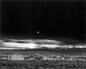
But one exposure was all that was needed.  He had captured Moonrise over Hernandez, New Mexico for all time.  If there is such a thing, Moonrise is the perfect environmental photograph.  The broad expanse of sky, mountains and land demonstrate the overpowering strength of nature.  The village in the foreground illustrates the essential interaction between humans and nature, which provides the resources needed for life.  And the white crosses remind us that the life of the individual is fleeting, but the population and species continues.

And, of course, the photograph is a masterpiece of composition, beauty and technical skill.  Over his life, Adams made about 1300 prints of Moonrise.  Today a print can bring more than $500,000 at auction.  One estimate puts the total value of Moonrise prints at $25 million.

A photograph of such beauty, fame and value begged another question:  When was it taken? Ansel Adams, who had frequently frustrated his publishers by not recording or remembering when he had taken a photo, could only shrug.  During the fall in the early 1940s, he guessed.

The photograph, however, offered many clues to its birthdate, given the right expertise and equipment to interpret the data.  The definitive answer came from a 1980 analysis by a solar physicist at the High Altitude Observatory in Boulder, Colorado.  Based on the position of the moon, lighting of various mountain peaks and other clues from topographic maps and surveyor’s instruments, all filtered through a computer, he pinpointed the exact date and time:  4:03 PM on October 31, 1941.  Adams, who was still alive at the time, was delighted to have the mystery solved. “Yippee!” he wrote to the scientist.

Only one problem—he was wrong.  When an amateur astronomer, Dennis di Cicco, grew interested in the dating process, he tried to reproduce the results—and failed.  Upon further analysis, it seems the computer used in the original analysis had distorted the image.  The scientist was embarrassed and admitted the error.  Dennis di Cicco stayed on the trail, and eventually corrected for the distortion.

The real birthday of the photograph was about a day later, exactly 4:49:20 PM on November 1, 1941.

References:

Ansel Adams Gallery.  Ansel Anecdotes.  Available at:  http://anseladams.com/ansel-adams-anecdotes/.  Accessed October 31, 2017.

Grant, Daniel.  2011.  The Market for Ansel Adams and Moonrise, Hernandez, New Mexico.  Artnet.  Available at:  http://www.artnet.com/magazineus/features/grant/ansel-adams-moonrise-hernandez-8-31-11.asp.  Accessed October 31, 2017.

Haederle, Mike.  1991.  It is Ansel Adams’ single most popular picture.  And no one, not even the photographer, was sure when it was made.  Until now. ‘Moonrise’ Mystery.  Los Angeles Times, October 31, 1991.  Available at:  http://articles.latimes.com/1991-10-31/news/vw-757_1_ansel-adams.  Accessed October 31, 2017.

Phaidon.  2014 Photos that change the world” #3 Moonrise.  Available at:  http://www.phaidon.com/agenda/photography/articles/2014/september/22/photos-that-changed-the-world-3-moonrise/.  Accessed October 31, 2017.

Lincoln Highway Dedicated (1913)

Most historians consider the completion of the transcontinental railroad in 1869 to be the end of the frontier era in America.  The country had become tied together coast-to-coast, with citizens able to travel in relative ease and safety across the nation in a short time.  A similar event—the dedication of the Lincoln Highway—occurred on October 31, 1913, paving the way for reliable automobile travel and ushering in the American love affair with cars.

The automobile was gaining popularity and reliability in the early 1900s, but travel was restricted primarily to local use.  The cause?  Bad roads, or no roads, extending for long distances.  Carl G. Fisher, an Indianapolis entrepreneur and car enthusiast, understood the problem:  “The automobile won’t get anywhere until it has good roads to run on.”  And he had a solution:  Establish a roadway from New York City to San Francisco that would be paved from end to end.  And to give it an All-American flavor, name that road the “Lincoln Highway” after the nation’s most popular president.

Fisher formed the Lincoln Highway Association and began the work of raising friends and funds.  His idea was to build the road with private money, but that soon gave way to using private funds for marketing and encouraging local and state governments and civic groups to pay the construction costs.  The next task was to pick a route.  Fisher and his friends set out on a “Trail-Blazer” tour in the summer of 1913, crisscrossing the country for 34 days.  They were greeted everywhere as celebrities by local dignitaries hoping the road would pass through their communities.

The chosen route was 3,389 miles long, following a hodge-podge of historical pathways once used by Native Americans, westward pioneers, the Pony Express and others.  When the route was announced and the highway dedicated on October 31, 1913, cities along the route held celebrations with bonfires, fireworks, parades and speeches.

Gradually—very gradually—the goal of paving the entire length of the route gained ground and a “highway” emerged.  By the time of the road’s formal opening in 1928, all but 42 miles of the route had been paved, and that section was under construction.  Eventually, the highway received the designation as U.S. Route 30 along most of its length, and the name Lincoln Highway fell out of use.  For those of us who grew up in and around Chicago, the radio ads for “the beautiful U.S. 30 Dragstrip” were a constant reminder of the importance of the route.

As a symbol and, perhaps, driver of American car culture, the Lincoln Highway’s start provides a useful milepost.  When the project began, the U.S. had 190,000 miles of paved roads (that is, covered with something other than dirt); today, the country has 2.7 million paved miles, a 14-fold increase.  In 1913, the U.S. had 13 vehicles per 1000 people; today, the country has 830 vehicles per 1000 people, a 64-fold increase.  The U.S. has more vehicles per capita than any country in the world, except Monaco (go figure…).  With 4.5% of the world’s population, the U.S. consumes 20.7% of the world’s petroleum, a rate nearly 5 times the average for the rest of the world.  We do love our cars!


When my wife and I visit her hometown in central Illinois, we sometimes drive the back roads along what is known as the “Lincoln Heritage Trail.”  Signs resembling the Lincoln penny mark the routes that Lincoln traversed through Kentucky, Indiana and Illinois.  I wonder what Lincoln would think about our addiction to cars and travel today.

Two of Lincoln’s quotes seem apropos.  First, he said, “I walk slowly, but I never walk backward.”  Undoubtedly, Lincoln would envy our ability to get around efficiently, comfortably and quickly.  He would probably also encourage us sometimes to move a little more slowly, to smell those roses, to take the back roads.

Second, he said, “The best way to predict the future is to create it.”  Undoubtedly, Lincoln would also admire the ingenuity and capability of the American people to invent a transportation system so remarkable.  But, he would also drive us not to rest on our past accomplishments, but aim for a better future.  He’d worry over issues of climate change caused by gas-burning vehicles, habitat losses to road building and the stresses and inefficiency of traffic congestion.

Today, I’m sure, he would tell us that the future we should be creating is a future of sustainable, carbon-neutral transportation.

References:

Oak Ridge National Laboratory.  2016.  Transportation Energy Data Book.  35th Edition, Oak Ridge National Laboratory.  Available at:  http://cta.ornl.gov/data/index.shtml.  Accessed October 30, 2017.

U.S. Department of Transportation.  2017.  National Transportation Statistics.  Bureau of Transportation Statistics.  Available at:  https://www.rita.dot.gov/bts/sites/rita.dot.gov.bts/files/publications/national_transportation_statistics/index.html#chapter_1.  Accessed October 30, 2017.

Weingroff, Richard F.  2017.  The Lincoln Highway.  U.S. Department of Transportation, Federal Highway Administration, Highway History.  Available at:  https://www.fhwa.dot.gov/infrastructure/lincoln.cfm.  Accessed October 30, 2017.

Golden Gate and Gateway National Recreation Areas Created (1972)

What is the most visited National Park Service property?  No, not Grand Canyon, not Yosemite, not even Great Smoky National Park.  The most visited property—and the fifth most visited property, as well—are “urban parks” in the San Francisco and New York City areas.  Golden Gate National Recreation Area (NRA) and Gateway NRA were created on October 27, 1972, representing a revolution in our national park philosophy.

Without question, our national parks and related properties—national monuments, national seashores and rivers, battlefields, historic parks and others—are treasures.  After World War 2, however, the National Park Service began to examine their mission in light of a growing and diversifying population.  They created “Mission 66,” a new program to guide a coming era of park expansion and changing operations.  Their analysis showed they were only servicing some Americans, not all.  To enjoy the most spectacular parks in the rural West, one needed a car, a long vacation and considerable cash.  Outdoor recreation was predominantly white recreation.

During the 1960s, a number of chronic social issues bubbled to the surface, including civil rights and environmental quality.  Embedded in those issues was the separation of urban populations, including the working poor and ethnic minorities, from the nation’s public resources.  In a major strategic adjustment to its mission, the National Park Service began to add urban parks to its inventory.

The crown jewel of that strategy is Golden Gate NRA.  Golden Gate emerged from two post-WW2 trends.  First, the military had excess lands in many places, including large holdings around San Francisco Bay.  Second, the growing population, especially in the West, was putting development pressure on open lands adjacent to major cities, like San Francisco.  When a major project was proposed to sell military lands to private developers for housing subdivisions around the bay, civic groups rose in unison to propose an alternative—a new park for the urban residents of San Francisco.

California Congressman Phillip Burton became the champion for the idea.  Burton believed that the nation should have “parks for the people, where the people are.”  Known as a fighter for the “little guy,” he crusaded for local outdoor recreation for all people, regardless of wealth, status or ethnicity.  On October 27, 1972, he achieved his signature success when President Nixon signed the law creating Golden Gate.  On the same day, the President created a companion park on the opposite coast to serve the people of the New York City metropolitan area—Gateway NRA.

Golden Gate NRA is huge—covering more than 80,000 acres, it is the largest urban park in the world.  In 2016, it received 15.6 million visits, the most of any National Park Service property, averaging 42,000 visits per day.  The park includes 19 distinct ecosystems distributed among 7 watersheds and is part of the UNESCO Golden Gate Biosphere Reserve.  It is home to the 3rd largest number of federally protected species among the 400+ units of the National Park Service.  But it is also an important historical and cultural site, encompassing 1200 historic structures and Alcatraz Island.

Gateway NRA is similar.  It exists as a series of peninsulas and coastal stretches surrounding New York harbor, covering 26,000 acres in all.  In 2016, it was the fifth most visited NPS unit, with 8.7 million visits.  Within the park lies the Jamaica Bay Wildlife Refuge, a major stopping point for birds migrating along the Atlantic flyway.  It has been a “flyway” for humans as well, with several historic airfields within the park.  Most of the nation’s daredevil aviators of the 1920s and 1930s, including Wiley Post, Howard Hughes, Charles Lindbergh, Amelia Earhart and “Wrongway” Corrigan, flew in and out of the park’s airfields.

The distinctive feature of these parks, however, is much less the elements within them than where they are located.  The resources are spectacular, of course, with beaches, marshes and forests, but the reality that these areas have been preserved for the enjoyment of urban Americans makes them true natural resource treasures.

References:

National Park Service.  Congressman Phillip Burton.  Available at:  https://www.nps.gov/goga/learn/historyculture/congressman-phillip-burton.htm.  Accessed October 27, 2017.

National Park Service.  Creation of Golden Gate National Recreation Area.  Available at:  https://www.nps.gov/goga/learn/historyculture/creation-of-golden-gate-national-recreation-area.htm.  Accessed October 27, 2017.

National Park Service.  Facts About Golden Gate National Recreation Area.  Available at:  https://www.nps.gov/goga/learn/news/upload/GGNRA_factsFY13-2.pdf.  Accessed October 27, 2017.

National Park Service.  1991.  Gateway National Recreation Area.  Available at:  https://www.nps.gov/parkhistory/online_books/gate/urban_park.pdf.  Accessed October 27, 2017.

Erie Canal Opens (1825)

I’ve got an old mule and her name is Sal
Fifteen years on the Erie Canal
She’s a good old worker and a good old pal
Fifteen years on the Erie Canal
We’ve hauled some barges in our day
Filled with lumber, coal, and hay
And every inch of the way we know
From Albany to Buffalo

So go the lyrics to the folksong, “Low Bridge, Everybody Down,” written in 1905 by Thomas Allen.  From the time the Erie Canal was completed and opened, on October 26, 1825, to today, the Erie Canal represents the epitome of American vision, ingenuity and practical capability.

The Erie Canal was the brainchild of DeWitt Clinton, a lawyer and politician who served as a New York legislator, senator and governor.  Because of his dogged determination to build the canal, the project was called “Clinton’s Ditch” during his day.

The project was massive, the biggest public works initiative in the history of the new nation.  When completed, it ran 363 miles from the Hudson River at Albany to Lake Erie at Buffalo.  Along the way, 83 locks raised the waterway 571 feet from East to West, and 18 aquaducts carried the canal over rivers.  The original canal was 40 feet wide and 4 feet deep, accompanied by tow-paths on both shores that allowed teams of mules and horses to pull canal boats along their journeys.  Construction began on July 4, 1817 and ended eight years later, as Clinton poured a bucket of Lake Erie water into the ocean at New York.

When completed, it was often called the Eighth Wonder of the World.  The canal became a symbol of American can-do spirit.  The canal had immediate positive results for the nation, and former skeptics shrank into the background.  The trip by stagecoach from Albany to Buffalo had taken two weeks of back-breaking travel; by canal, it took five days in relative comfort. More importantly, it opened markets from the Midwest to the country’s eastern seaboard, assuring inexpensive and healthy food supplies and a stable economy for farmers.  As each section of the canal opened, expansion of commerce followed, mile after mile from Albany westward.

Within a few years, the canal reached capacity and needed to be expanded.  Between 1836 and 1862, the width was increased to 70 feet and the depth to 7 feet.  From 1903 to 1918, the canal was enlarged again and became known as the Erie Barge Canal.  The locks were reduced to 36, much deeper and wider than earlier, speeding travel.  The canal still operates today, but mostly for recreational boats.

What is the conservation message?  First, of course, the ability of humans and nature to work together to accomplish meaningful improvements in civilization is the essence of conservation.  Second, however and more specifically, the Erie Canal illustrates the importance of water-borne transportation.  Moving materials, especially heavy and bulky products like coal, oil, rock and concrete, by water remains the most efficient and safest form of transportation.  In terms of greenhouse gases produced per ton of cargo, barge transportation is a bargain compared to railroad and, especially, truck transportation.

The US Army Corps of Engineers maintains 12,000 miles of navigable waterways, mostly along the coasts and through the Mississippi and Ohio River valleys.  These waterways transport 60% of total grain exports, 22% of petroleum production and 20% of coal used for electricity production.

The Erie Canal and its various branches are now featured in a unique National Park Service unit called the Erie Canalway National Heritage Corridor.  The corridor, created in 2000, encompasses the entire upstate New York region, specifically highlighting 524 miles of navigable waterways.

References:

Erie Canalway.  Erie Canalway National Heritage Corridor.  National Park Service.  Available at:  https://eriecanalway.org/.  Accessed October 25, 2017.

The Erie Canal.  “Clinton’s Big Ditch.”  Available at:  http://www.eriecanal.org/index.html.  Accessed October 25, 2017.

The Erie Canal.  DeWitt Clinton.  Available at:  http://www.eriecanal.org/UnionCollege/Clinton.html.  Accessed October 25, 2017.

U.S. Department of Transportation.  Waterways:  Working for America.  Maritime Administration, US DOT.  Available at:  https://www.marad.dot.gov/wp-content/uploads/pdf/water_works_REV.pdf.  Accessed October 25, 2017.

This Month in Conservation

May 1
Linnaeus Publishes “Species Plantarum” (1753)
May 2
“Peter and The Wolf” Premieres (1936)
May 3
Vagn Walfrid Ekman, Swedish Oceanographer, Born (1874)
May 4
Eugenie Clark, The Shark Lady, Born (1922)
May 5
Frederick Lincoln, Pioneer of Bird Banding, Born (1892)
May 6
Lassen Volcanic National Park Created (1907)
May 7
Nature’s Best Moms
May 8
David Attenborough Born (1926)
May 9
Thames River Embankments Completed (1874)
May 10
Birute Galdikas, Orangutan Expert, Born (1946)
May 11
“HMS Beagle” Launched (1820)
May 12
Farley Mowat, Author of “Never Cry Wolf,” Born (1921)
May 13
St. Lawrence Seaway Authorized (1954)
May 14
Lewis and Clark Expedition Began (1804)
May 15
Declaration of the Conservation Conference (1908)
May 16
Ramon Margalef, Pioneering Ecologist, Born (1919)
May 17
Australian BioBanking for Biodiversity Implemented (2010)
May 18
Mount St. Helens Erupts (1980)
May 19
Carl Akeley, Father of Modern Taxidermy, Born (1864)
May 20
European Maritime Day
May 21
Rio Grande Water-Sharing Convention Signed (1906)
May 22
International Day for Biological Diversity
May 23
President Carter Delivers Environmental Message to Congress (1977)
May 24
Bison Again Roam Free in Canada’s Grasslands National Park (2006)
May 25
Lacey Act Created (1900)
May 26
Last Model T Rolls Off the Assembly Line (1927)
May 27
Rachel Carson, Author of “Silent Spring,” Born (1907)
May 27
A Day for the birds
May 28
Sierra Club Founded (1892)
May 29
Stephen Forbes, Pioneering Ecologist, Born (1844)
May 30
Everglades National Park Created (1934)
May 31
The Johnstown Flood (1889)
January February March April May June July August September October November December