Watson and Crick Discover The Double Helix (1953)

The Eagle is a famous pub not far off the high street in Cambridge, England.  The pub has been in operation forever, it seems, but it owes part of its fame to the American Air Force servicemen who frequented The Eagle during World War II.  The walls and ceiling are filled with graffiti left by the soldiers.

Francis Crick, 1995 (photo by National Cancer Institute)

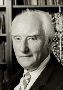
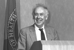
But it owes its more recent fame to the corner table where biologists James Watson and Francis Crick generally came for lunch or a drink and discuss their work on the mechanisms of genetics.  And there, on February 28, 1953, they celebrated the conceptual breakthrough that is the basis for all we know about genetics today:  the structure of DNA, the double helix.

Knowledge of the fundamentals of genetics was advancing rapidly at the time, including the understanding that deoxyribonucleic acid (DNA) was the building block for holding genetic information and transferring it to the next generation.  But no one had figured out how it was done.  Watson and Crick decided that discovering the three-dimensional structure of the gene was the key to unlocking the genetic mysteries.  Just like the American flyers who relaxed at The Eagle had set their sights on German airplanes, Watson and Crick set their sights on the structure of DNA.

James D. Watson (photo by National Cancer Institute)

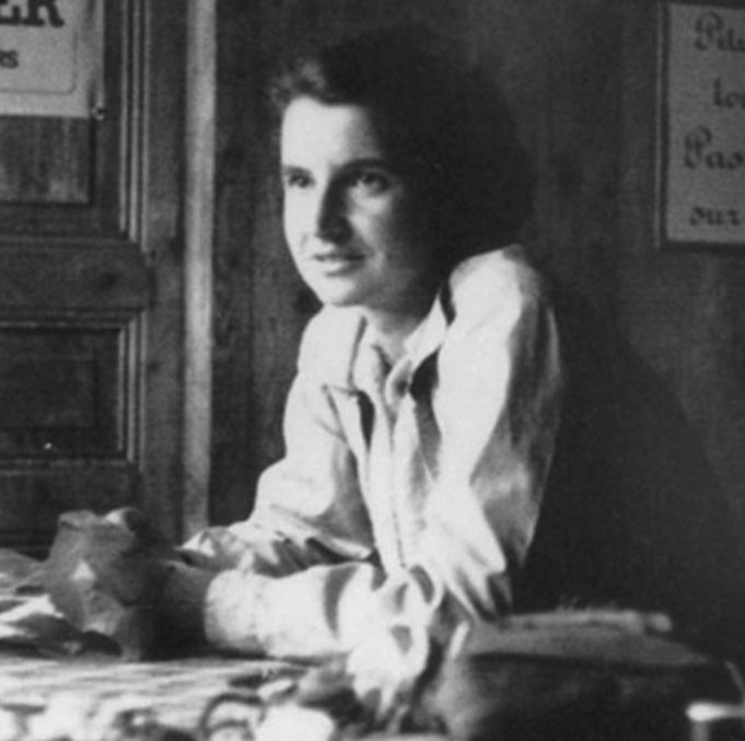
An essential step in the unmasking of DNA was the work of their colleague, Rosalind Franklin.  Franklin was a physical chemist who had made her reputation studying the structures of other organic compounds.  She was an expert at X-ray photography and her photographs of DNA gave Watson and Crick a fundamental idea about the structure of the compound.  As both Watson and Crick subsequently and frequently reported, their discovery could not have occurred without her work (had she not died from ovarian cancer in her late thirties, today we might be talking about Watson, Crick and Franklin as three, not two, scientists credited with the discovery).  Franklin and another collaborator of Watson and Crick’s, Maurice Wilkins, had used x-ray crystallography to suggest that DNA formed a corkscrew-shaped helix in three dimensions. 

Rosalind Franklin deserves to be include as one discoverer of DNA (photo by CSHL)

Another colleague, biochemist Erwin Chargaff, had deduced that four compounds (the bases adenine, guanine, cytosine and thymine) were always present in DNA and that adenine (A) and thymine (T) were always present in equal amounts, and the same for cytosine (C) and guanine (G).  While working with cardboard models, Watson realized that two strands of the sugar-phosphate chains could be linked by hydrogen bonds of pairs of A on one strand and T on the other, or C on one strand and G on the other.  When modeled this way, the structure was stable in a double helix. They had found the correct structure!

Not only was the structure consistent with all other evidence, but it provided the answer to how genetic information was transferred.  The two strands split, and a new strand formed on the empty hydrogen bonds, A to T and C to G.  With new strands built on the two separated parts of the double helix, an exact replica of the original compound was formed.  And, when mistakes were made in the process, mutation occurred.

Watson and Crick went to lunch at The Eagle that day, triumphant over their discovery.  Crick told the lunch crowd that they had “found the secret of life.”  They published a one-page paper on their discovery in Nature on April 25, 1953, and a more complete version a month later (the same issue of the journal also included a paper by Franklin and her student that independently came to the same conclusion).

Well, of course, Watson, Crick, Franklin and Wilkins hadn’t discovered the secret of life, but certainly one of the secrets.  Their discovery did provide the basis for understanding the mechanisms of genetics, and that itself has been enormously useful in understanding the processes that lead to diversity in nature.  Because diversity is the essence of our use of nature, these scientists might just be among the most important conservationists of all time!

References:

Maddox, Brenda.  2003. The double helix and the “wronged heroine.”  Nature 421:407-408.  Available at: https://rdcu.be/clsdJ.  Accessed May 27, 2021.

National Institutes of Health.  The Francis Crick Papers; The Discovery of the Double Helix, 1951-1953.  NIH U.S. National Library of Medicine.  Available at:  https://profiles.nlm.nih.gov/SC/Views/Exhibit/narrative/doublehelix.html.  Accessed February 23, 2018

Four National Parks Established (1917-1929)

February 26 has an important history in conservation.  On this date, four national parks were established, all within an era of active national park activity, from 1917-1929.

When the National Park Service (NPS) was created in August, 1916 (read more here), a new era of park management—and creation—began.  Created by an Organic Act and housed in the Department of Interior, the NPS had the authority, budget and workforce to become more active in stewardship of our great national heritage of nature, history and culture.  The expansion of the national park system began in earnest and continued for several decades.

Denali National Park (photo by David Dugan)

The first park created under the new NPS was Mount McKinley National Park in Alaska (now Denali National Park).  The debate over creating a large park in the middle of the state had gone on for years—some saw the park as an advantage for future tourism, but most Alaskans wanted access to the land for subsistence and market hunting and for mining.  Spurred by the dauntless energy of Charles Sheldon, however, and by an American populace energized to preserve the western “wilderness,” President Woodrow Wilson signed the park into law on February 26, 1917, almost six months to the day after the NPS was formed.  In the first year of recorded visitation (1922), 7 hardy souls went to the new park; in 2016, nearly 600,000 took the same journey.

Grand Canyon postcard from 1903 (photo by Bruck & Sohn)

Two years exactly after Denali came Grand Canyon National Park, also signed into existence by President Wilson, in 1919.  But the Grand Canyon had traveled a long administrative path on its way to park status, with little of the controversy of other parks.  Protection was first given to the canyon in 1893, as a “federal forest reserve.”  Teddy Roosevelt furthered the protection by declaring part of the area a “federal game reserve” in 1906.  Then, in 1908, motivated on by the passionate entreaties of his friend, John Muir, President Roosevelt elevated the canyon’s status to a national monument, providing the complete protection that eventually led to national park status.  Annual visitation now stands at 6 million, among the most visited of our national parks.

Glacier Bay National park (photo by Dmitry Brant)

Another big chunk of Alaska was preserved on February 26, 1925, when the Glacier Bay National Monument was created by the executive order of President Calvin Coolidge (now glacier Bay national Park and Preserve).  Like Denali, the establishment of this monument was controversial.  The area covered a huge part of southeastern Alaska’s archipelago, rich in timber, game and mineral resources that many Alaskans wanted to develop.  The fight for preservation was led by the Ecological Society of America, a scientific group that saw the area as a critically important biodiversity resource and as a unique research location.  The 3 million acres of Glacier Bay is now also part of the larger 25-million-acre UNESCO World Heritage Site.  Annual visitation is about 500,000.

the Cathedral Group in Grand Teton national Park (photo by Acroterion)

The fourth action on February 26—this time in 1929—was to create Grand Teton National Park.  It was established on this date as a national monument, seeking to protect the Grand Teton mountain range and the lakes that lie at its base from development.  John D. Rockefeller was an active proponent of the park and donated some 30,000 acres to its later enlargement.  In 1943, the monument was reclassified as a national park.  Grand Teton is the southern gateway to Yellowstone National Park.  More than 3 million people visit the park annually.

References:

Anderson, Michael F.  2000.  Administrative History of Grand Canyon National Park.  National Park Service.  Available at:  https://www.nps.gov/grca/learn/historyculture/adhigrca.htm.  Accessed February 16, 2018.

Brown, William E.  1991.  A History of the Denali-Mount McKinley, Region, Alaska.  National Park Service.  Available at:  https://www.nps.gov/parkhistory/online_books/dena/hrs.htm.  Accessed February 16, 2018.

Catton, Theodore.  1995.  Land Reborn:  A History of Administration and Visitor use in Glacier Bay National Park and Preserve.  National Park Service.  Available at:  https://www.nps.gov/parkhistory/online_books/glba/adhi/index.htm. Accessed February 16, 2018.

Discovergrandteton.org.  Park history.  Available at:  http://www.discovergrandteton.org/park-history/prehistoric-indians/.  Accessed February 16, 2018.

International Polar Bear Day

February 27 has been designated as the annual International Polar Bear Day by the conservation organization, Polar Bears International.  The day has been celebrated annually since 2012.  The annual event seeks to educate the general public about the plight of polar bears globally and to encourage individuals to reduce their greenhouse gas emissions by turning down their heat and turning up their air conditioners.  Polar Bears International lists its mission as seeking to “conserve polar bears and the sea ice they depend on.”

Polar bear on an ice flow in Ukkusiksalik National Park, Nunavut, Canada (photo by Ansgar Walk)

The polar bear (Ursus maritimus) is superbly adapted to living in the frigid conditions of the Arctic ecosystem.  It is a marine species by definition (hence its scientific name), living on floating sea ice as its preferred habitat.  Its main food is the ringed seal, which also lives on and around sea ice and is a fat-rich dietary source needed by bears.  Polar bears are evolved from a common ancestor with the brown bear (grizzly bear).  They grow to 9 feet in length and 1400 pounds in weight.  During summer when sea ice disappears, polar bears must retreat to land.  Food is insufficient for the bears on land, and they lose weight during the time they must spend off the ice.

Consequently, global warming is a primary threat to the survival of polar bears.  Arctic sea ice has been disappearing rapidly, with the area of ice decreasing every summer and the length of time ice habitat is available to bears also decreasing.  Each year, bears are spending longer on land, losing more weight, emerging in the fall in worse condition, and having smaller cubs that have higher post-natal mortality.  Photographs of emaciated polar bears, trapped on tiny ice floes, are heart-rending reminders of their plight.

U.S. researchers study sea ice in the Arctic (photo by Donald K. Perovich)

For these reasons, polar bears are receiving higher levels of protection around the world.  The International Union for the Conservation of Nature (IUCN) has declared the species “vulnerable” to extinction.  IUCN estimates that together the 19 distinct populations of polar bears around the Arctic region number about 22,000-31,000 individuals.  However, detailed knowledge of their abundance is scarce, as the animals live in remote areas that are largely inaccessible to humans.  The Convention on International Trade in Endangered Species (CITES), a treaty to which the U.S. is party, regulates global trade in the species, but still allows some harvest (learn more about CITES here).

In the United States, the polar bear is listed as a “threatened” species under the Endangered Species Act.  It is also protected under the Marine Mammal Protection Act, which in general prohibits hunting and other forms of exploitation of polar bears.  However, Native Americans in the Arctic region can harvest polar bears for subsistence uses and native handicrafts.

In recent years, the status of polar bear populations has become controversial. Overall, population numbers are up from a century ago, because of restrictions on over-exploitation. But worries over declining levels of sea ice have led many observers to speculate that polar bears are on a long-term slide toward extinction. Contrasting ideas suggest that declining sea ice will not be an issue for several polar bear generations to come. The competing views are possible because data are scarce, but the charistmatic polar bear continues to attract attention from advocacy groups and the press.

References:

CITES.  CITES and Polar Bear.  Available at:  https://cites.org/eng/news/sg/2013/20131203_polar-bear.php. Accessed February 26, 2017.

Polar Bears International.  The Life, Land, and Future of the Polar Bear.  Available at:  http://polarbearsinternational.org/. Accessed February 26, 2017.

U.S. Fish and Wildlife Service.  2013.  U.S. Fish and Wildlife Service Announces Final Polar Bear Special Rule.  Available at:  https://www.fws.gov/alaska/external/newsroom/pdf/13-04.pdf?SiteName=FWS&Entity=PRAsset&SF_PRAsset_PRAssetID_EQ=131878&XSL=PressRelease&Cache=True. Accessed February 26, 2017.

Winter, Emery. 2022. It’s misleading to claim that polar bears are ‘thriving’ because of ‘increasing population’. Verify, December 29, 2022. Available at: https://www.verifythis.com/article/news/verify/environment-verify/polar-bear-population-thriving-population-rising-claim-misleading-misrepresents-data/536-0eb6146f-fb8c-437a-a97c-59625228187a. Accessed February 12, 2023.

World Widlife Fund.  Polar bear status, distribution & population.  Available at:  http://wwf.panda.org/what_we_do/where_we_work/arctic/wildlife/polar_bear/population/.  Accessed February 26, 2017.

First Federal Timber Act Passed (1799)

Today the U. S. Forest Service oversees the management of about 232 million acres of our nation’s forests and related ecosystems.  But it had to start somewhere.  That starting point was the first federal law dealing with forestland—the Federal Timber Purchases Act of February 25, 1799.

Sunset over Blackbeard Island National Wildlife Refuge (photo by U.S. Fish and Wildlife Service Southeast Region)

The 1799 act gave the government authority to purchase wood and land to provide resources for the navy.  The primary target was the live oak, which grows in the southeastern U.S. and was highly coveted as a material for wooden ships—decking, framing for hulls and other needs that required large planks of wood.  The government purchased two islands off the Georgia coast—Blackbeard and Grover Islands.

The 1799 act was followed with an amendment in 1817 that authorized the government to buy a number of islands in Louisiana, also filled with live oak forest.  Another act, in 1827, reserved about 30,000 acres near Pensacola, Florida.  This was intended to be the first forest experiment station, where research into the silviculture of live oaks could be conducted.  Unfortunately, politics intervened and no research occurred.

The Penobscot research forest is a special use area of the National Forest Ssystem (photo by USFS Northern Research)

New laws and new presidential decrees kept adding timber holdings to the lands reserved for their use to grow live oak for the navy.  Through 1860, about 200,000 acres of live oak forest had been set aside for conservation, to assure a steady supply of high quality live oak resources.  With the transition to steel-hulled and power ships after 1860, the need for these reserves declined, and over the next half century, all of the live oak reserves were sold off or turned to other purposes.  For example, the two original reserves were given new lives; the 5,600-acre Blackbeard Island is now a National Wildlife Refuge, and the much smaller Grover Island is now in private ownership.

Map of the U.S. National Forests and Grasslands (U..S. Forest Service)

From these early laws and commitments to conserving important forest lands came our current National Forest System.  Today, the U.S. Forest Service administers 283 separate units, composed of 154 national forests (97% of all their lands), 20 national grasslands (2%) and about 100 smaller units for various specialized purposes (1%).

Most federal forests are in the western U.S. (about 70%) and Alaska (10%).  Only about 20% of federal forests are in the eastern U.S.  The states holding the most federal forest land are California (24 million acres), Alaska (24), Idaho (22), Montana (19) and Oregon (17).  Several eastern states have no federal forest land (Delaware, Maryland, Massachusetts and Rhode Island), and Connecticut has just 23 acres.

References:

Sullivan, Buddy.  2003.  Blackbeard Island.  New Georgia Encyclopedia, July 17, 2003.  Available at:  https://www.georgiaencyclopedia.org/articles/geography-environment/blackbeard-island.  Accessed February 15, 2018.

U.S. Forest Service. 2017.  Land Areas report (LAR) – as of September 30, 2017.  Available at:  https://www.fs.fed.us/land/staff/lar/LAR2017/lar2017index.html.  Accessed February 15, 2018.

Williams, Gerald W.  2003.  Private Property to Public Property:  The Beginnings of the National Forests in the South.  American Society for Environmental History, Providence, RI, March 26-30, 2003.  Accessed February 15, 2018

Joseph Banks, British Botanist, Born (1743)

Perhaps the most influential of Britain’s many botanical explorers, Joseph Banks was born on February 24, 1743 (died 1820).  He explored the world collecting plant specimens, and he led the early development of Kew Royal Botanical Gardens.

Portrait of Joseph Banks by Joshua Reynolds

Banks was born to a wealthy and privileged family.  He attended the best schools, including Eton, where he learned to love plants, specifically the wildflowers that grew around the school’s grounds.  He went on to study botany at Cambridge, famously paying personally for a botany professor who could advance Banks’s knowledge.  His father died when Banks was 18, leaving him in control of several estates and a large personal fortune.  Rather than dallying in polite society, as many did, Banks applied his funds to his botanical explorations.

His early explorations took him to Labrador and Newfoundland, but it was his voyage with Captain Cook that earned his place in history.  He accompanied Cook on his first voyage to the South Pacific, from 1768 to 1771, sailing on the Endeavour.  Banks contributed 10,000 British pounds to fund the outfitting of the ship for scientific work (equal to many millions in today’s money).  He sailed with Cook for three years, visiting South America, the South Pacific islands, Australia and New Zealand.  He collected specimens of more than 3000 plant species, 1300 of which were new to European science.  The flora of Australia was so astonishing to Banks that he named one collecting point Botany Bay (later to become famous as the location of a prison). The specimens from the voyage formed the nucleus of the botanical collection for the British Museum (those collections were later transferred to the new London Natural History Museum) (learn more about the British Museum here).

Bust of Sir Joseph Banks at Kew Royal Botanical Gardens Herbarium (photo by Larry Nielsen)

Banks had been made a member of the Royal Society before the voyage, but upon returning his status was highly elevated.  He was elected president in 1778, and held that position for the next 42 years until his death.  He became the scientific advisor to King George III.  A particularly important royal duty for Banks was as director of what would become the Kew Royal Botanical Gardens.  Banks dispatched voyages around the world to bring back living specimens for the gardens, thousands of species from across the world.  He was particularly interested in plants that would be useful for economic purposes—agriculture, medicine, textiles, ornamentation.  Since then, Kew has become the world’s leading botanical repository for both growing plants and for seeds preserved in cold-storage.

(Note:  There seems to be some confusion about the actual date of Banks’s birth.  It is stated as February 13 in several references, but this is apparently the “Old Style” of dating from British history.  Other references cite the birth as occurring on February 24, the date I have used.)

Specimen collected by Joseph Banks on voyage with Captain Cook to South Pacific (photo by Larry Nielsen)

References:

Encyclopedia Britannica.  Sir Joseph Banks, British Naturalist.  Available at:  https://www.britannica.com/biography/Joseph-Banks.  Accessed February 14, 2018.

Endersby, Jim.  2014.  How botanical gardens helped establish the British Empire.  Financial Times, July 25, 2014.  Available at:  https://www.ft.com/content/dcd33da0-0e69-11e4-a1ae-00144feabdc0.  Accessed February 14, 2018.

Gilbert, L. A.  1966.  Banks, Sir Joseph (1743-1820).  Australian Dictionary of Biography, Volume 1 (MUP), 1966.  Available at:  http://adb.anu.edu.au/biography/banks-sir-joseph-1737.  Accessed February 14, 2018.

PlantExplorers.com.  Joseph Banks 1743-1820.  Available at:  https://www.plantexplorers.com/explorers/biographies/banks/joseph-banks-01.htm.  Accessed February 14, 2018.

Italy’s Largest Inland Oil Spill (2010)

Italy suffered its largest inland oil spill on February 23, 2010, when millions of gallons of oil was maliciously drained into a tributary of the Po River.  Considered an act of sabotage—perhaps in retaliation by dismissed workers—the perpetrators have never been caught.

The Po River near Turin, Italy (photo by Giuseppe zeta)

The discharge occurred from storage tanks along the Lambro River, an upstream tributary of the Po River.  The Po is Italy’s longest river, flowing 400 miles west to east across the northern expanse of the nation, from the border with France and Switzerland to the Adriatic Sea just south of Venice.  The river drains about a quarter of the Italian land mass, making it the largest watershed in Italy and one of the largest in Europe.  The valley of the Po, called the Pianura Padana, is home to 17 million Italians (one-third of the total population), the cities of Milan and Turin, and the rich agricultural districts of Lombardy, Liguria, Emilia Romagna and others.

The spill occurred when saboteurs released 825,000 gallons of diesel fuel and fuel oil from tanks at an abandoned petroleum refinery about 20 miles north of Milan.  The oil entered the Lambro River and shortly reached the main stem of the Po River.  The Lambro has been considered the most polluted river in the entire Po basin, which includes more than 140 separate streams and small rivers.  The oil slick extended over one mile and continued moving rapidly down the Po River, eventually reaching the Adriatic seacoast.

Although the release probably occurred at the hands of disgruntled refinery workers, Italian authorities called it “a true act of environmental terrorism.”  Observers recorded hundreds of dead and moribund ducks and other birds, and fishermen along the river described the situation as “a stinking mess.”

This spill, however serious, ranks well down the list of major oil spills.  The biggest in Italian waters was the breakup and sinking of the oil tanker MT Haven, off the coast at Genoa on April 11, 1991.  A total of 44 million gallons were released.  The largest purposeful release of oil occurred during the first Gulf War, when retreating Iraqi troops sabotaged Kuwait oil wells and terminals, releasing 168 million gallons into the Persian Gulf and billions of gallons onto the Kuwait landscape (learn more about this spill here).

References:

Giari, L. et al.  2012.  The impact of an oil spill on organs of bream Abramis brama in the Po River.  Ecotoxicology and Environmental Safety 77(1 March 2012):18-27.  Available at:  http://www.sciencedirect.com/science/article/pii/S0147651311003393.   Accessed February 22, 2017.

Mosello, Beatrice.  2015.  How to Deal with Climate Change?  Springer International Publishing, Switzerland.  (Chapter 4 – The Po River Basin).  Available at:  http://link.springer.com/chapter/10.1007/978-3-319-15389-6_4#page-1.  Accessed February 22, 2017.

Oiled Wildlife Care Network.  210.  Italy Oil Spill.  Available at:  https://owcnblog.wordpress.com/2010/03/01/italy-oil-spill/.  Accessed February 22, 2017.

Squires, Rick.  2010.  Italy’s longest river facing catastrophe after oil spill.  The Telegraph, 25 Feb 2010.  Available at:  http://www.telegraph.co.uk/news/worldnews/europe/italy/7315220/Italys-longest-river-facing-catastrophe-after-oil-spill.html.  Accessed February 22, 2017.

Nile Day

February 22 has been declared Nile Day by the countries that share the Nile River basin.  Nile Day commemorates the signing of the 1999 agreement to cooperatively manage the river basin, called the Nile Basin Initiative.

Nile River and delta (image by Jacques Desclorites, NASA)

The Nile River is one of the most important waterbodies in the world.  By most estimates, it is the longest river in the world, flowing from south to north for 4180 miles.  It carries water from the relatively water-rich regions in its upper watershed through the dry regions of The Sudan and then Egypt.  Once past Cairo, the river splits into multiple channels, entering the Mediterranean Sea through a broad delta.

The main tributaries are the Blue Nile, which arises in the mountains of Ethiopia, and the White Nile, which flows out of Lake Victoria in Uganda.  The Blue and White Niles join to form the Nile River at Khartoum, the capital of The Sudan.  About two-thirds of the river’s annual flow comes from the Blue Nile.  Adding in the flows from other smaller tributaries, approximately 90% of all the water in the Nile originates in Ethiopia.

The Nile River’s water has been crucial to the development of the civilizations that flanked its banks, from ancient times to the present.  The monuments created by past civilizations—the Pyramids at Giza, the Sphinx, and the tombs of Egyptian kings and queens—are considered among the great wonders of the ancient world.

The Grand Ethiopian Renaissance Dam (photo by Hailefida/Wikipedia)

Today, the wonders of the Nile Basin are more closely tied to the engineering technology of the post-World War 2 era.  Complementing other smaller dams and irrigation structures, the Aswan High Dam was completed on the river in 1970.  The dam created Lake Nasser, which stretches 300 miles south from the dam, crossing the border from Egypt to The Sudan.  The dam provides hydro-electricity throughout Egypt.  Lake Nasser allows flood water to be stored both for use during the hot, dry parts of every year, but also from one year to the next, counteracting the impacts of both floods and droughts.  A second major dam has recently been completed on the Blue Nile by the nation of Ethioplia.  The dam, named the Grand Ethiopian Renaissance Dam (GERD), will provide massive amounts of hydro-electricity and allow similar water-storage capabilities as the Aswan High Dam farther downstream. However, both Egypt and Sudan view the creation of GERD as a threat to their management of the downstream regions of the Nile River, including their ability to generate power and control water storage to prevent floods and droughts. Although the three countries signed a “declaration of principles” in 2015, they remain at odds over the new dam.

Eleven African nations (Burundi, the Democratic Republic of Congo, Egypt, Eritrea, Ethiopia, Kenya, South Sudan, The Sudan, Rwanda, Tanzania and Uganda) share part of the Nile River basin.  Because the river is so important to the livelihoods of all, ten of the countries banded together by creating the Nile Basin Initiative in 1999 (Eritrea participates as an observer).  The Initiative has the stated vision “to achieve sustainable socio-economic development through the equitable utilization of, and benefit from, the common Nile Basin water resources.”   The Initiative is headed by a committee of the water ministers of the member countries; its headquarters is in Entebbe, Uganda.

Nile Day moves among the members countries from year to year.  Billed as an event to increase awareness of the Nile River’s importance, events bring together representatives from throughout the basin to develop strategies for enhancing the sustainability of the basin’s environment.  The first Nile Day was held in 2007.

References:

Al-Anani, Khalil. 2022. The Grand Ethiopian Renaissance Dam: Limited Options for a Resolution. Arab Center of Washington DC, Sept 16, 2022. Available at: https://arabcenterdc.org/resource/the-grand-ethiopian-renaissance-dam-limited-options-for-a-resolution/. Accessed February 10, 2023.

New World Encyclopedia.  Nile River.  Available at:  http://www.newworldencyclopedia.org/entry/Nile_River.  Accessed February 21, 2017.

Nile Basin Initiative.  Nile Day Celebration, 22nd February 2017.  Available at:  http://www.nilebasin.org/index.php/media-center/documents-publications/48-regional-nile-day-2017-flyer/file.  Accessed February 21, 2017.

Nile Basin Initiative.  Available at:  http://www.nilebasin.org/.  Accessed February 21, 2017.

Carolina Parakeet Goes Extinct (1918)

The last known Carolina Parakeet (Cornuropsis carolinensis) died in captivity at the Cincinnati Zoo on February 21, 1918.

Carolina Parakeet (display mount at Field Museum of Natural History, Chicago; by James St. John)

Carolina Parakeets were common birds in the eastern United States at the time of European settlement.  Sir Walter Raleigh mentioned their presence in the Carolinas in a 1596 book, comparing them to the parrots he had encountered in Central America.  It was, in fact, a species of parrot, the only species in its genus.

They were much larger than our modern image of domesticated “parakeets,” more similar in size and shape to the Mourning Dove—about a foot long with a wingspan just under two feet.  And they were brightly colored—a green body grading into a yellow neck and head, ending in a reddish orange crown and bill.  The birds were noisy and highly social, gathering together in large flocks, sometimes so large that early observers said they blocked out the sun.  They did not migrate, apparently, but spent a great deal of time in the air—they preferred to fly rather than climb, walk or hop, even just to turn around on a branch.  No one seems to know where they nested, but amateur ornithologists of the time thought they used cavities such as hollow trees.  Consequently, they were most common in forests, along wooded edges and forested river bottoms.

Illustration of Carolina parakeet by John James Audubon

From great abundance, they fell rapidly to low levels and eventually extinction by about 1900.  The causes of extinction are many, and somewhat mysterious.  The birds were hunted for food and for their beautiful feathers, highly desired for decorations on Victorian ladies dresses and hats. The birds aggregated in large flocks, which responded to alarm calls of individuals not by fleeing, but by flying to the location of the distressed birds.  Consequently, when hunters shot one bird, many others came to the sound—making massive killing easy.  Ecologists also surmise that the spread of honeybees, introduced into the eastern U.S. in colonial times, caused competition for nesting sites, and the birds lost out to the bees.  In the end, however, the last wild individuals probably succumbed to diseases caught from domestic poultry.

The last wild individual Carolina Parakeet was reportedly killed in Okeechobee County, Florida, in 1904.  The last known specimen, a male named Incas, died in captivity at the Cincinnati Zoo, on February 21, 1918.  Curiously, the last specimen died in the same aviary where the last known Passenger Pigeon, Martha, had died four years earlier (read more here).

References:

Colvin, Thagard.  No date.  The Extinct Carolina Parakeet.  Outdoor Alabama.  Available at:  http://www.outdooralabama.com/extinct-carolina-parakeet.  Accessed February 20, 2017.

John James Audubon Center at Mill Grove.  The last Carolina Parakeet.  Available at:  http://johnjames.audubon.org/last-carolina-parakeet.  Accessed February 20, 2017.

Powell, William S.  2006.  Carolina Parakeet.  Encyclopedia of North Carolina.  Available at:  http://www.ncpedia.org/carolina-parakeet.  Accessed February 20, 2017.

Ansel Adams, Nature Photographer, Born (1902)

Ansel Adams, the most famous nature photographer in history, was born on February 20, 1902 (died 1984), in San Francisco, California.  The work of Ansel Adams is ubiquitous in the United States—in museums, government offices, calendars and pinned to the walls in college dorm rooms.  No other photographer of nature has captured either the American landscape or the American consciousness as fully as Ansel Adams.

Ansel Adams in 1950 (photo by J. Malcolm Greany)

He was born into a rich family of western timber barons at a boom time in the American West.  A particular boom—the 1906 San Francisco earthquake—left its mark on Adams.  An aftershock of the earthquake threw him to the ground, breaking his nose.  Not set correctly, his crooked nose was a visual signature throughout his life.

Adams was a difficult child, unsuccessful in school, unpopular with other children and, perhaps, what we would today call hyperactive.  Consequently, after failing in several schools, he was home-schooled by his father and aunt.  The piano became his primary friend—he taught himself to play and to read music.  His skill grew to the level of a concert pianist, and he intended playing the piano as his career.

Nature was also his friend.  He spent most days hiking the hills and coast around his home.  In 1916, a trip to Yosemite totally captured his attention—and kept his attention for his entire life.  The Sierra Nevada Mountains became his playground and his inspiration.  Before long, he was photographing the mountains, learning a new trade that gradually attracted his full commitment and became his real career.  It took some time before his artistic photography took off, so for many years he was a commercial photographer, snapping everything from portraits to fruit to retail catalogues.

Canyon de Chelly National Monument, Arizona, photographed by Ansel Adams in 1941.

As a young man, he became a member of the Sierra Club, participating in their high mountain activities and working for them, first as a trip counselor and then as photographer (learn more about the Sierra Club here).  The Sierra Club gave Adams’s photographs their first public exposure—and neither he nor the club ever looked back.  Along the way, Adams became not only a nature photographer, but a vigorous advocate for parks, wilderness and environmental protection.  His photographs became the core of a 1930s book created as evidence of the need for more national parks.  It worked, convincing President Franklin Roosevelt and his Secretary of Interior, Harold Ickes, to set aside Kings Canyon National Park in 1940 (learn more about Ickes here).

Aside from his environmental impact, Ansel Adams was a journeyman photographer of enormous skill.  His technical talent was renown, as he perfected techniques for “straight photography”—letting the images speak for themselves, rather than being manipulated by the photographer or developer.  As a dedicated black-and-white photographer, he marked the pinnacle of art photography before color images became the norm.

Ansel Adams in 1980 (hoto by Los Angeles times)

Adams worked and played hard.  From excursions into the wilderness to marathons in the darkroom, he seldom took a day off.  But he was equally known as a gracious host, a gregarious companion and, in general, the life of every party.  He was a man of the American West, but spent long periods in New York as part of the art photography scene.

The true impact of Adams’s work, however, is unquestionably his vast landscapes of the American West.  His signature photograph was taken only weeks before the Japanese attack on Pearl Harbor, on November 1, 1941—“Moonrise, Hernandez, New Mexico” (see more here).   The moon is suspended in a dark sky over the spreading mountains and obliquely-lit town of Hernandez.  He and companions were driving along the highway after a disappointing day of shooting around Santa Fe.  He glanced to his left, saw the image, slammed on the brakes and rushed to take the shot just as the light was disappearing.  Later he said, “Sometimes I do get to places just when God’s ready to have somebody click the shutter.”

Ansel Adams got to many places just when the shutter needed clicking, and our world is a more beautiful and inspirational place because of it.

References:

National Archives.  Ansel Adams Photographs.  Available at:  https://www.archives.gov/research/ansel-adams.  Accessed February 19, 2017.

Sierra Club.  History:  Ansel Adams.  Available at:                         http://vault.sierraclub.org/history/ansel-adams/.  Accessed February 19, 2017.

The Ansel Adams Gallery.  Ansel Adams, Photographer.  Available at:  http://anseladams.com/ansel-adams-bio/.  Accessed February 19, 2017.

Lincoln Boyhood National Memorial Established (1962)

Which U.S. presidents have been the most environmentally important?  Opinions vary, but generally included in the top 5 is a name you might not expect—Abraham Lincoln.  And the place where Abraham Lincoln learned to love the land was established as the Lincoln Boyhood National Memorial on February 19, when President John Kennedy signed it into law.

President Abraham Lincoln in 1863 (photo by Alexander Gardner)

Abraham Lincoln is often associated with Illinois—the Land of Lincoln—because that was where he lived as an adult.  But it was in southern Indiana that he grew up.  In 1816, when Lincoln was seven, his family moved from Kentucy to a homestead along Little Pigeon Creek, near the town now known as Lincoln City, Indiana. He lived there for 14 years, leaving for Illinois at the age of 21.  Lincoln remembered his time there:  “We reached our new home about the time the State came into the Union. It was a wild region, with many bears and other wild animals still in the woods. There I grew up.”

Indeed, this is where he learned to carve a homestead from the wilderness and to farm.  He became skilled with an ax, so much so that he became known as “the rail-splitter.”  He learned to read and devoured every book he could find.  His two favorite tools, he said, were a book and an ax.  He spent time working on a flatboat on the Ohio and Mississippi Rivers, learning the ways of nature and the ways of people.

Abraham Lincoln as a boy at his home in southern Indiana

After the Lincoln’s moved on to Illinois, the legacy of his time in Indiana gradually began to disappear.  But in the 1930s, the state of Indiana created the Lincoln State park, designed partly by Frederick Law Olmsted, Jr., to preserve the original homestead.  In 1962, one-hundred acres of that park were deeded to the U.S. government for the creation of the Lincoln Boyhood National Memorial.  The park opened in 1964.

The Memorial contains the site of the Lincoln’s original cabin, plus a living history reconstruction of an 1820s-era farm.  A 1940s-era limestone building serves as a tableau of his early life and legacy.  Visitation is not high, hovering around 125,000 annually since it opened.

But for environmentalists, visiting should be a pilgrimage.  For Abraham Lincoln was one of our most environmentally important presidents, even though his importance overall—as the president who rid the country of slavery and held it together through a civil war—far overshadows his environmental reputation.

The foundation of Lincoln’s boyhood home, all that remains (photo by Cool10191)

Lincoln established the U.S. Department of Agriculture, which then and now guides our nation’s production of food—and today is a significant force in environmental sustainability.  He created the National Academy of Sciences, which performs essential research and analysis on the most pressing environmental issues for today and the future.  He authorized the system of public Land-Grant Universities which produce most of today’s environmental professionals and environmental research.  He transferred to California the land that would become Yosemite National Park—on the condition that the land be preserved for public recreation.

So, next time you are traveling across southern Indiana on Interstate 64, take exit 57, head a few miles south and spend some time walking in the footsteps of one of the true pioneers of our environmental consciousness.

References:

Fabricius, Karl.  2008.  The 5 Most Environmentally Friendly President in U.S. History.  Scribol, February 28, 2008.  Available at:  http://scribol.com/uncategorized/the-5-most-environmentally-friendly-presidents-in-u-s-history/.  Accessed February 13, 2018.

National Park Service.  Lincoln Boyhood National Memorial.  Available at:  https://www.nps.gov/nr/travel/presidents/lincoln_boyhood.html.  Accessed February 13, 2018.

O’Bright, Jill York.  1987.  “There I Grew Up…,” A History of the Administration of Abrahma Lincoln’s boyhood Home.  National Park Service.  Available at:  https://www.nps.gov/parkhistory/online_books/libo/adhi/adhi.htm.  Accessed February 13, 2018.

This Month in Conservation

April 1
Wangari Maathai, Kenyan Conservationist, Born (1940)
April 2
Maria Sibylla Merian, German Entomologist, Born (1647)
April 3
Jane Goodall, Chimpanzee Researcher, Born (1934)
April 4
“The Good Life” Begins Airing (1975)
April 5
Civilian Conservation Corps (CCC) Created (1933)
April 6
American Museum of Natural History Founded (1869)
April 7
World Health Day
April 8
A Tribute to the Endangered Species Act
April 9
Jim Fowler, “Wild Kingdom” Co-host, Born (1932)
April 10
Arbor Day First Celebrated (1872)
April 11
Ian Redmond, Primatologist, Born (1954)
April 12
Arches National Monument Created (1929)
April 13
First Elephant Arrives in U.S. (1796)
April 14
Black Sunday Dust Storm (1935)
April 15
Nikolaas Tinbergen, Animal Behaviorist, Born (1907)
April 16
Ling-Ling and Hsing-Hsing Arrive in U.S. (1972)
April 17
Ford Mustang Introduced (1964)
April 18
Natural History Museum, London, Opened (1881)
April 19
E. Lucy Braun, Plant Ecologist, Born (1889)
April 20
Gro Harlem Brundtland, Godmother of Sustainable Development, Born (1939)
April 21
John Muir, Father of American Conservation, Born (1838)
April 22
The First Earth Day (1970)
April 23
World Book Day
April 24
Tomitaro Makino, Father of Japanese Botany, Born (1862)
April 25
Theodore Roosevelt National Park Established (1947)
April 26
John James Audubon Born (1785)
April 27
Soil Conservation Service Created (1935)
April 28
Mexican Gray Wolf Listed as Endangered (1976)
April 28
Chernobyl Nuclear Accident Announced (1986)
April 29
Emmeline Moore, Pioneering Fisheries Scientist, Born (1872)
April 29
Dancing with Nature’s Stars
April 30
First State Hunting License Fee Enacted (1864)
January February March April May June July August September October November December